
Introduction
![]() Although it is normally associated with Langstrath, Angle Tarn actually sits on a shelf between Rossett Pike and Tongue Head, just above the head of the valley. To the south the crags of Bow Fell and Esk Pike loom over the tarn, but because of its high altitude there are wider views to the north and east. To the east the summit of Rossett Pike is less than 200 feet above the tarn, so the fell only appears as a slight outcrop.
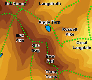
Although it is normally associated with Langstrath, Angle Tarn actually sits on a shelf between Rossett Pike and Tongue Head, just above the head of the valley. To the south the crags of Bow Fell and Esk Pike loom over the tarn, but because of its high altitude there are wider views to the north and east. To the east the summit of Rossett Pike is less than 200 feet above the tarn, so the fell only appears as a slight outcrop.
![]() Although Angle Tarn is at the very end of a long valley, it is also on the busy footpath from Great Langdale to Esk Hause via Rossett Gill, and so gets a steady stream of visitors. The path cuts across the northern end of the tarn, leaving the craggy southern side rather quieter.
Although Angle Tarn is at the very end of a long valley, it is also on the busy footpath from Great Langdale to Esk Hause via Rossett Gill, and so gets a steady stream of visitors. The path cuts across the northern end of the tarn, leaving the craggy southern side rather quieter.
Statistics
Grid Reference of centre: NY 244 076
Altitude: 1,850ft
Map
How to Reach
![]() Angle Tarn sits alongside the fairly busy path from Great Langdale to Esk Hause and the Scafell range.
Angle Tarn sits alongside the fairly busy path from Great Langdale to Esk Hause and the Scafell range.
To reach it from Great Langdale follow the path up Rossett Gill. At the top of the climb the path climbs over the col between Bow Fell and Rossett Pike, and at this point Angle Tarn comes into view just ahead.
From Borrowdale follow the long path up Langstrath. Just before the head of the valley take the path that climbs up alongside Angletarn Gill.
From the true Esk Hause head north towards the shelter near the false Esk Hause (on the way to Allen Crags). Turn right here and follow a path that drops down to cross a bowl in the hills at the top of Allencrags Gill, then drops down again reach to Angle Tarn.
Walks
Our ascent of Scafell Pike from Langdale visits Angle Tarn twice.
Inflows
A number of small unnamed becks flow into Angle Tarn from the slopes of Bow Fell and Esk Pike
Outflow
Angletarn Gill flows north out of the tarn, drops down into Langstrath and merges with Allencrags Gill to form Langstrath Beck.
Other Features
-