
 The River Brathay has two distinctive stretches. In its upper reaches it is the river of Little Langdale, running along the entire length of that valley from Wrynose Pass to Elter Water. After Elter Water the river runs around the southern flanks of Loughrigg Fell on its way to Windermere.
![]() The most familiar stretch of the Brathay is that between Skelwith Bridge and Windermere, where it runs alongside the A 593, while the most visited area must be the section just above Skelwith Bridge, where a rare riverside footpath takes one past Skelwith Force and up to Elter Water. The upper stretches, in Little Langdale, are rather more difficult to access, lacking footpaths. The upper Brathay is probably most often seen in nervous glimpses by people driving up Wrynose Pass.
The most familiar stretch of the Brathay is that between Skelwith Bridge and Windermere, where it runs alongside the A 593, while the most visited area must be the section just above Skelwith Bridge, where a rare riverside footpath takes one past Skelwith Force and up to Elter Water. The upper stretches, in Little Langdale, are rather more difficult to access, lacking footpaths. The upper Brathay is probably most often seen in nervous glimpses by people driving up Wrynose Pass.
The Brathay is formed by the junction of Wrynose Beck and Widdy Gill, just to the east of Wrynose Pass.
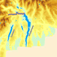
![]() For most of its course the Brathay runs due east, from its source below Wrynose Pass to the point it merges with the Rothay. The only exception comes at the end of Little Langdale where a spur of high ground forces it to make a diversion to the north that brings it into Elter Water, although below that lake the river returns to its original course and continues to run east from Skelwith Bridge.
For most of its course the Brathay runs due east, from its source below Wrynose Pass to the point it merges with the Rothay. The only exception comes at the end of Little Langdale where a spur of high ground forces it to make a diversion to the north that brings it into Elter Water, although below that lake the river returns to its original course and continues to run east from Skelwith Bridge.
The rivers Rothey and Brathay merge just to the north of Windermere and flow together into the lake.
Widdy Gill, Wrynose Beck
Bleamoss Beck
Greenburn Beck (in Little Langdale Tarn)
Ben Beck
Great Langdale Beck (in Elter Water)