
Introduction
Broad Crag is the fourth highest peak in the Scafell range, coming after Scafell Pike, Scafell and (just) Ill Crag, although it is normally treated as a subsidiary summit of Scafell Pike. Huge numbers of walks pass within a few feet of the summit but hardly anyone takes the time to scramble up the difficult rocky slopes to reach the top - on a normal foggy day on Scafell Pike it really isn't worth the effort, but on a good sunny day the top is well worth a visit.
![]() Broad Crag has the least tamed top of any fell in the Scafell range. Scafell Pike is equally covered in boulders, but the greater numbers of people and path works have slowly created clear routes. On Broad Crag the boulder field remained largely undisturbed. The path across the top is marked by a series of small cairns, and some scratch marks on the rocks (although modern walking boots don't mark rock in the same way as older boots with metal studs).
Broad Crag has the least tamed top of any fell in the Scafell range. Scafell Pike is equally covered in boulders, but the greater numbers of people and path works have slowly created clear routes. On Broad Crag the boulder field remained largely undisturbed. The path across the top is marked by a series of small cairns, and some scratch marks on the rocks (although modern walking boots don't mark rock in the same way as older boots with metal studs).
The Scottish Mountaineering Club considers Broad Crag to be a 'Furth Munro', a mountain in Britain but outside Scotland that would be a Munro if it was north of the border. If this view was more widely followed then England would have six mountains over 3,000ft rather than four.
In form Broad Crag is a simple round mountain with impressive crags to the north and south and connected by cols to Scafell Pike in the west and Ill Crag to the east. The northern face is the largest and most impressive and looms over parts of the Corridor Route up Scafell Pike. The southern face is much smaller, and is squeezed between Scafell Pike and Ill Crag. These cliffs are seen to good effect from the top of Scafell Pike (with the best views coming from the slopes just to the north-east of the summit).
![]() The top of Broad Crag is similar in form to that of Scafell Pike (as I discovered on one especially grim foggy day when wishful thinking convinced my party that we were one peak further along the ridge than we really were - it was only when we reached the top and found no cairn and no people that the awful truth dawned!).
The top of Broad Crag is similar in form to that of Scafell Pike (as I discovered on one especially grim foggy day when wishful thinking convinced my party that we were one peak further along the ridge than we really were - it was only when we reached the top and found no cairn and no people that the awful truth dawned!).
Broad Crag first comes into site for the walker approaching from Esk Hause when the path reaches the eastern end of the Ill Crag plateau. At this point Broad Crag is just in front of Scafell Pike in the view, and the large gap between the two fells isn't at all obvious - that nasty surprise comes rather later in the walk!
Statistics
Grid Reference of Summit: NY 218 075
Height: 934ft
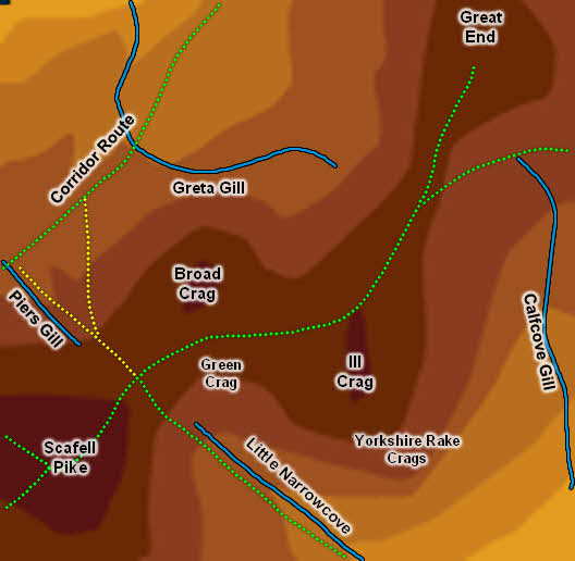
Map
Routes of Ascent
Broad Crag is best approached from the path between Scafell Pike and Calf Cove/ Esk Hause. After climbing up from either col follow the line of cairns that mark out a rough route across the fell until this route begins to drop, then turn north and make your own way (carefully) to the summit.
Walks
Two of our walks cross Broad Crag - Scafell Pike via Sty Head and Scafell Pike from Great Langdale. In both cases the summit can visited by a scramble up the jumble of rocks to the north of the cairned route.
The Summit
![]() The summit of Broad Crag is a jumbled mass of large boulders that pile up to a jagged peak. There isn't a path to the summit, but then there aren't clear paths across the entire summit area!
The summit of Broad Crag is a jumbled mass of large boulders that pile up to a jagged peak. There isn't a path to the summit, but then there aren't clear paths across the entire summit area!
Streams and Tarns
Broad Crag is divided from Scafell Pike by Piers Gill in the north and Little Narrowcove Beck in the south. No streams flow from the gap between Ill Crag and Broad Crag. To the north-east Greta Gill runs across the foot of Broad Crag. Greta Gill flows into Piers Gill just below the foot of the crags, so Broad Crag can claim a sizable if rather odd shaped section of the rugged ground below the Corridor Route.
There are some small tarns close to the Corridor Route as it runs below the northern crags of Broad Crag.
Other Features
The Corridor Route, my favourite way up Scafell Pike, runs across a gentle ledge in the middle of the northern crags of Broad Crag, with great views up to the cliffs that protect the summit.