
Introduction
![]() Brandreth is probably the least well known of the fells that surround the head of Ennerdale, sitting between Haystacks and Green Gable. Brandreth is one of those fells that sees thousands of walkers, hardly any of whom actually visit the summit. The Moses Trod path that runs from the Honister quarries to Wasdale and the coast passes across the western slopes of the fell and is used by walkers heading for Great Gable from the top of Honister Pass, but hardly anyone diverts up to the top of Brandreth. The Great Gable path splits from Moses Trod on Brandreth's western slopes, but still avoids the climb.
Brandreth is probably the least well known of the fells that surround the head of Ennerdale, sitting between Haystacks and Green Gable. Brandreth is one of those fells that sees thousands of walkers, hardly any of whom actually visit the summit. The Moses Trod path that runs from the Honister quarries to Wasdale and the coast passes across the western slopes of the fell and is used by walkers heading for Great Gable from the top of Honister Pass, but hardly anyone diverts up to the top of Brandreth. The Great Gable path splits from Moses Trod on Brandreth's western slopes, but still avoids the climb.
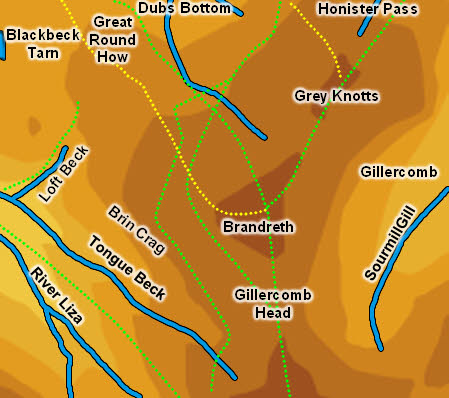
![]() Brandreth is the southern part of a larger area of high ground, running north towards Grey Knotts. To the south it runs down to Ennerdale and to the east to Gillercomb, but to the north-west its boundaries are less clear-cut - Loft Beck forms a boundary with Haystacks, while a tributary of Warnscale Beck forms a dividing line with Grey Knotts, but between them is an area of broken rocky ground around Great Round How, Little Round How and the crags above Warnscale Bottom. A look at the contours would suggest that Brandreth can claim a footing on Blackbeck Tarn and a narrow spit of land between Black Beck and Warnscale Beck, although the summit feels very distant from this area, which feels much more like part of Haystacks.
Brandreth is the southern part of a larger area of high ground, running north towards Grey Knotts. To the south it runs down to Ennerdale and to the east to Gillercomb, but to the north-west its boundaries are less clear-cut - Loft Beck forms a boundary with Haystacks, while a tributary of Warnscale Beck forms a dividing line with Grey Knotts, but between them is an area of broken rocky ground around Great Round How, Little Round How and the crags above Warnscale Bottom. A look at the contours would suggest that Brandreth can claim a footing on Blackbeck Tarn and a narrow spit of land between Black Beck and Warnscale Beck, although the summit feels very distant from this area, which feels much more like part of Haystacks.
![]() Brandreth's most impressive face is the eastern front facing Gillercomb, but this is rarely seen to full effect, being hidden behind Base Brown. Only walkers heading for Great Gable via Sourmilk Gill or those on Base Brown will get the full view of this slope. Those on the busy paths from Honister will only see the gentle grassy slopes on the western side of the fell.
Brandreth's most impressive face is the eastern front facing Gillercomb, but this is rarely seen to full effect, being hidden behind Base Brown. Only walkers heading for Great Gable via Sourmilk Gill or those on Base Brown will get the full view of this slope. Those on the busy paths from Honister will only see the gentle grassy slopes on the western side of the fell.
Statistics
Grid Reference of Summit: NY 214 119
Height: 715m/
Map
Routes of Ascent
Brandreth can be reached from Ennerdale either by the path alongside Loft Beck or by the path up Tongue (between Tongue Beck and the River Liza), which joins Moses Trod in Stone Cove. A good path runs from the Honister-Haystacks path, passing to the right of Great Round How (ignore the marked right of way, which isn't clear on the ground).
Away from paths the eastern slopes are generally too steep to be attempted, but the northern and north-western slopes are gentle enough to be climbed in just about any direction.
Walks
We have a walk that begins with Haystacks before moving on to climb Brandreth and Grey Knotts, before returning to Buttermere.
The Summit
The summit has a mix of grass and exposed rocks, making an change from the grassy lower slopes. The summit area formed a triangular pyramid, with slightly steeper slopes than the surrounding fell, so in most directions the views are good.
Streams and Tarns
On the Ennerdale flank Tongue Beck forms the southern boundary and Loft Beck the western.
In the north a tributary of Warnscale Beck is the dividing line with Grey Knotts. On the Gillercomb side Sourmilk Gill forms the eastern boundary, but there is no clear dividing line with Grey Knotts.
To the north-west the fell can claim a finger of land between Warnscale Beck and Black Beck, ending where the becks meet just above Warnscale Bottom.
Brandreth can stake a claim to the eastern bank of Blackbeck Tarn. There are also pools on the ridge leading to Grey Knotts and at Gillercomb Head, on the ridge to Green Gable.
Other Features
-