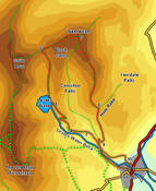
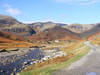
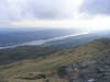
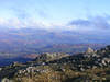
 This walk from Coniston takes us to the summit of Wetherlam, a fantastic viewpoint that benefits from its position on the edge of the higher ground of the Coniston Fells. As a result there are sweeping views away to the north and east, as well as down into Little Langdale.
Ascent: 2,370ft
Length: 6.5 miles
Map: The English Lakes - South Western Area (OS Explorer Map Active) Last Walked:
We will start by the church in the centre of Coniston
1: SD 302 975
From the church cross the bridge over Church Beck. On the far side of the bridge turn right onto the first small side-road. Follow this road as it curves around to the left. Just before this road joins a slightly larger one at a T-junction a small lane leaves to the right. Turn right onto this lane and follow it as it runs north-west, emerging from the last buildings in the village and crosses some open fields before reaching a small patch of woodland. This brings us to some workshops in the woods, which we bypass to the right, continuing on in the same direction, now with Church Beck to the right.
2: SD 294 980
We follow this track until we reach a bridge over the beck. Cross this bridge and then turn left to continue up the valley, now with the beck to the left.
3: SD 289 985
This soon brings us into a large bowl in the hills that was once the site of large-scale industrial activity. The ruins of some of the industrial buildings still remain, as does a beautifully located Youth Hostel. Although the right of way is marked as passing to the left of the hostel, the easiest route onwards is to follow the track as it runs to the left of the hostel.
4: SD 285 986
Soon after passing the Youth Hostel we come to a crossroads in the tracks. Turn right here, and follow this track as it climbs up the hillside, curving around to the left. Our route now zig-zags up the hillside, heading towards
Levers Water. Follow this first track until it is running west, parallel to a second track just above it on the hillside, then take the first suitable route onto that track, Turn right, and follow this track until a path branches off to the left. Follow this path until it reaches another track, then turn left and follow this track all the way up to the tarn.
5: SD 281 992
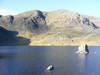
The track stops abruptly at the edge of the tarn, but a path continues on along the right-hand shore. Follow this path past Levers Water, and then continue along it as it climbs up the valley beyond the tarn, all the way to Swirl Hause, where the view suddenly expands to include the fells around the Langdales.
6: NY 278 007
At Swirl Hause turn right. Follow this path all the way to the summit of Wetherlam, with the drop down to Greenburn to the left.
7: NY 288 011
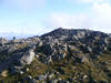
Turn right at the summit, and follow the path that runs south along the gently southern slopes of the fell. Ignore any paths that branch away to the sides, and follow the path along the highest part of this long ridge.
8: SD 293 991
Eventually this path drops down into Hole Rake, a narrow valley that separates Wetherlam from Sweeten Crag. Turn right onto the path that runs through this valley and follow it as it runs back down into the Coppermine Valley.
9: SD 293 984
Near the valley bottom we reach an area criss-crossed with paths. At the first junction turn sharply right, then at the next one equally sharply to the left, and follow this path down to the track we used earlier in the walk. Follow this track south, this time ignoring the bridge we used at step two.
10: SD 300 979
After twisting and turning its way down the fellside this track brings us to the edge of Coniston village. Follow it through the village to reach the main road close to the bridge, or turn left to visit the Ruskin Museum.
