
Introduction
![]() Levers Water is a large almost rectangular tarn in the valley above Coniston village. Like a surprising number of the high tarns Levers Water is partly artificial, the water level having been raised in 1717 by the construction of a small dam to provide water for the Coniston Copper Mines. That doesn't distract from the setting, which is spectacular.
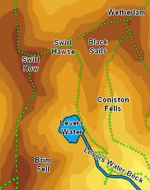
Levers Water is a large almost rectangular tarn in the valley above Coniston village. Like a surprising number of the high tarns Levers Water is partly artificial, the water level having been raised in 1717 by the construction of a small dam to provide water for the Coniston Copper Mines. That doesn't distract from the setting, which is spectacular.
The water is now used for Coniston village, with a treatment plant hidden in the valley below the tarn. This is impressive work, and the works are hardly visible from any distance. This contrasts with the older mining in the area, which has left visible scars, or the current quarry.
The tarn is surrounded on three sides by high fells, with the ridge running from the Old Man of Coniston across Brim Fell to Swirl How to the west and the Black Sails ridge of Wetherlam to the east.The view west across the tarn from the footpath is the most impressive, with a series of crags looming over the water.
Statistics
Grid Reference of centre: SD 279 992
Altitude: 1,350ft
Map
How to Reach
The obvious routes of approach come from Coniston Village. One route runs from the track behind the Ruskin Museum, which runs up the eastern side of Church Beck. A second runs up the road west from the cross-roads south of the beck, then follows a signposted footpath on the south side of the beck. The two routes merge at Miners Bridge, where we move to the northern bank and follow the track towards the Youth Hostel. Follow the well built track towards the Hostel, then past it to the left. A a track junction near the water plant take the right-hand branch, which begins to climb up towards the tarn. Follow the track as it turns sharply right and then left before finally reaching the tarn just to the right of the dam.
Walks
Our ascent of Wetherlam visits Levers Water.
Inflows
Swirl Hawse Beck flows into the northern tip of the tarn. A nameless beck runs parallel to its lower reaches and flows into the tarn just a little to the east.
A nameless beck rises on Little How Crags and runs south-east into the tarn.
Just to the south Cove Beck, which rises on Brim Fell, runs into the western tip of the tarn.
Outflow
Levers Water Beck flows out of the tarn.
Other Features
-