
 As the highest mountain in England, Scafell is the ultimate target for any fell walker. This is not the quickest route to the top, but the extra distance is justified, at least for me, by the visits to Sty Head and Sprinkling Tarns and the views of the crags of Great End.
One word of warning - the top of the Scafell Plateau is a rocky wilderness, with very few clear paths. On a clear day the route on is normally clear, but in thick fog some sections are very indistinct, especially around Broad Crag, where the thousands of walkers who pass this way have made little or no impact.
Ascent: 3,571ft
Length: 9.3 miles
Map: The English Lakes - South Western Area (OS Explorer Map Active)
Last Walked: August 2007
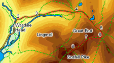
![]() Follow this path until you cross a small beck (Fogmire Beck). Immediately after crossing this beck, turn right onto a path and follow it along the side of the beck. We leave Fogmire Beck just after passing Burnthwaite farm and follow our path towards Lingmell Beck.
Follow this path until you cross a small beck (Fogmire Beck). Immediately after crossing this beck, turn right onto a path and follow it along the side of the beck. We leave Fogmire Beck just after passing Burnthwaite farm and follow our path towards Lingmell Beck.
Ignore the left turn we meet just after crossing a large footbridge (over Gable Beck) and continue on along the valley bottom.
![]() At Sty Head a very large number of paths meet, but our route on is actually fairly clear. At the top of the pass there is a ridge of high ground between the upper reaches of Wasdale and Styhead tarn. Turn right, and follow the clear path along this high ground. A very clear path climbs up towards Sprinkling Tarn, along the side of a small beck running through a ravine.
At Sty Head a very large number of paths meet, but our route on is actually fairly clear. At the top of the pass there is a ridge of high ground between the upper reaches of Wasdale and Styhead tarn. Turn right, and follow the clear path along this high ground. A very clear path climbs up towards Sprinkling Tarn, along the side of a small beck running through a ravine.
Follow this path to Sprinkling Tarn. From Sprinkling Tarn follow the path as it dips down across the head of Ruddy Gill, in the shadow of the crags of Great End.
You are now on the ridge that leads to Scafell Pike. This is a rough rocky wilderness, and can be very confusing in fog. Despite the thousands of people who have walked across this piece of ground, in places there is no clear path.
![]() The ridge walk begins with one of those rocky patches. Our path up from Esk Hause climbs up to the ridge, and then turns left, passing behind a crag. Follow the line of cairns that indicates the correct route.
The ridge walk begins with one of those rocky patches. Our path up from Esk Hause climbs up to the ridge, and then turns left, passing behind a crag. Follow the line of cairns that indicates the correct route.
This stretch is followed by an easier section, heading along the top of Ill Crag. Here the path is clearly visible on the ground. Follow this path as it dips down into the gap between Ill Crag and Broad Crag, running along the right hand side of the plateau, with views down towards the Corridor Route to the right.
This is perhaps the most difficult section of the path to follow, especially in the fog. At the bottom of this dip, the path turns slightly to the left and climbs up around the side of Broad Crag. In good weather the bulk of Scafell Pike is clearly visible and the correct route easy enough to find, but in fog it is easy to climb Broad Crag by mistake. If you are on the correct route, the path will lead down into the gap between Great End and Scafell Pike.
One last climb remains before the summit. The path is clear, rocky and steep. Follow it onto the summit, and head towards the unusual summit cairn.
For the purposes of this walk, return the same way, (especially in the mist and fog).
Bookmark this page:
 Delicious
![]() Facebook
Facebook
![]() StumbleUpon
StumbleUpon