
Introduction
Great End forms a dramatic northern end to the long ridge of high ground that makes up the Scafell Pike range. The summit only just fails to reach 3,000 feet, and its massive northern crags loom impressively above one of the major routes to Esk Hause.
![]() Great End makes a bigger impression than its southern neighbours on the ridge, Ill Crag and Broad Crag, despite being lower than either of them. Its position at the end of the ridge gives it that advantage, but also means that is its often free of visitors. Hundreds will pass along the Calf Cove path heading for Scafell Pike but only a handful make the short diversion needed to claim an extra summit.
Great End makes a bigger impression than its southern neighbours on the ridge, Ill Crag and Broad Crag, despite being lower than either of them. Its position at the end of the ridge gives it that advantage, but also means that is its often free of visitors. Hundreds will pass along the Calf Cove path heading for Scafell Pike but only a handful make the short diversion needed to claim an extra summit.
Statistics
Grid Reference of Summit: NY 225 084
Height: 910m
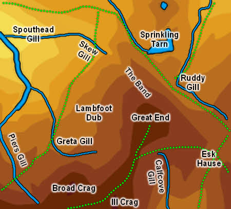
Map
Routes of Ascent
![]() There is only one footpath that leads onto Great End - the path from the pass at the top of Calf Cove, linking the fell to the rest of the Scafell range. Wainwright suggests other routes - one up the northern rocky ridge (Great End's Band) and a route up from the upper reaches of Greta Gill, on the opposite of the Calf Cove col. I've tried this second route and found it a good way up but not so clear from above.
There is only one footpath that leads onto Great End - the path from the pass at the top of Calf Cove, linking the fell to the rest of the Scafell range. Wainwright suggests other routes - one up the northern rocky ridge (Great End's Band) and a route up from the upper reaches of Greta Gill, on the opposite of the Calf Cove col. I've tried this second route and found it a good way up but not so clear from above.
Walks
None of our walks actually visit the summit of Great End, but it can easily be added to our ascent of Scafell Pike via Esk Hause.
The Summit
There are two summits on a rising rocky dome. The north-western summit is the higher of the two. The northern crags start a short distance to the north of the summit, so there is a gentle slope down
Streams and Tarns
Great End is in the middle of rather complex country, so it isn't entirely clear which streams form its boundaries. To the north the stream between Sprinkling Tarn and Styhead Tarn is one boundard, while the upper reaches of Ruddy Gill form the boundary with Allen Crags.
To the east the boundary is formed by Esk Hause. A narrow spit of territory runs between the upper reaches of the River Esk and Calfcove Gill. Calfcove Gill forms the boundary with Ill Crag.
On the western flanks the top of Lingmell Beck then Spouthead Gill forms a main boundary with Great Gable. Greta Gill begins just below the Ill Crag-Great End col, and runs west then north, before joining Piers Gill. The lower reaches of Piers Gill divide Great End and Lingmell. This north-western corner also includes the few becks to belong entirely to Great End.
The tarn most associated with Great End is Sprinkling Tarn, which sits at the foot of the northern crags, in a most dramatic location. Great End can also claim a small footing on the southern shore of Styhead Tarn.
Other Features
![]() Although the Scafell range seems a long way away from Keswick, the northern crags of Great End actually form the southern end of Borrowdale, with the valleys of Styhead Gill and Ruddy Gill running up towards it. The crags of Great End can be seen from the northern shores of Derwent Water, although they aren't always recognised.
Although the Scafell range seems a long way away from Keswick, the northern crags of Great End actually form the southern end of Borrowdale, with the valleys of Styhead Gill and Ruddy Gill running up towards it. The crags of Great End can be seen from the northern shores of Derwent Water, although they aren't always recognised.
Great End is also unusual in that it has a foot on two seperate major mountain passes, Styhead Tarn and the true Esk Hause.