
 This walk visits two of the most dramatic landmarks in the Yorkshire Dales - the giant dry waterfall of Malham Cove and the romantic ravine of Gordale Scar, as well as taking in Malham Tarn, the largest natural lake in Yorkshire, and visiting some of the quietest hills in the Dales, to the north of the tarn.
The northern part of this walk, on the hills above Malham Tarn, crosses access land on relatively unclear paths, and can be skipped by taking a shortcut east from Malham Tarn (see step 7).
Ascent: 1,900ft/
Length: 11 miles/
Map:
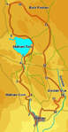
Map: Yorkshire Dales - Southern and Western Areas (OS Explorer Map Active) (OS Explorer Map Active)
Last Walked: 9 May 2008
This walk starts from the large car park at the southern edge of Malham village.
Our path onwards is clearly visible climbing around the left hand side of the Cove. For the moment ignore it and follow the path all the way to the base of the cove, where Malham Beck emerges from a cave at the base of the dramatic dry waterfall. After visiting the foot of the cove return to the main path, and follow it as it climbs up a long flight of steps. Eventually this path brings us to the limestone pavements at the top of the cove. There are some spectacular views across the cove from here, but take care around the edges.
![]()
![]()
![]()
Turn right onto the road. Follow it as it passes through a gate, then turn left onto a footpath that heads towards Malham Tarn (part of the Pennine Way).
![]()
![]()
![]() This path brings us to the southern tip of Malham Tarn. We are going to walk around the right hand bank of the tarn, for most of the time following the route of a lane that leads past the field centre at Malham House. To reach that lane follow the path that runs close to the edge of Malham Tarn, before swinging away a little to the right to pass around some trees.
This path brings us to the southern tip of Malham Tarn. We are going to walk around the right hand bank of the tarn, for most of the time following the route of a lane that leads past the field centre at Malham House. To reach that lane follow the path that runs close to the edge of Malham Tarn, before swinging away a little to the right to pass around some trees.
Once on the track turn left and follow it all the way around the northern side of the tarn, into the woods around Malham House, past the house and to the edge of the trees. Just before entering the trees a footpath leaves to the right, climbing up over the northern flank of Great Close Hill - if you want a shorter walk, then take this path over the top of this ridge and down to Middle House Farm (step 11 on the walk).
![]() After just over a third of a mile our path turns right, and heads up the hillside towards Back Pasture. The turning point is actually more obvious that seems likely on the approach - the path reaches a clear gully that heads up the hill, turns right and follows the base of this valley.
After just over a third of a mile our path turns right, and heads up the hillside towards Back Pasture. The turning point is actually more obvious that seems likely on the approach - the path reaches a clear gully that heads up the hill, turns right and follows the base of this valley.
![]() Our only real problem comes as the path reaches the limestone pavements. Here a stone wall crosses our route, and is not crossed by any stiles. Remember, although this is access land, walkers do not have the right to take any route they want - only those routes that will not do damage. The best route past this wall is to turn left, and follow the wall until it reaches the foot of a cliff. Here there is a gap between the end of the wall and the cliff face, which can easily be scrambled over.
Our only real problem comes as the path reaches the limestone pavements. Here a stone wall crosses our route, and is not crossed by any stiles. Remember, although this is access land, walkers do not have the right to take any route they want - only those routes that will not do damage. The best route past this wall is to turn left, and follow the wall until it reaches the foot of a cliff. Here there is a gap between the end of the wall and the cliff face, which can easily be scrambled over.
![]() On the far side of the wall an obvious path continues along the base of this gully, heading to the right of the crags that line the top of Back Pasture. This path passes around the southern tip of Back Pasture (it is well worth scrambling up this slope to see the view from the top). It then passes through a gap in the next stone wall, and passes to the south of a large flat wet area, before passing to the right of Back Pasture Hill. Here our faint path joins a much clearer track
On the far side of the wall an obvious path continues along the base of this gully, heading to the right of the crags that line the top of Back Pasture. This path passes around the southern tip of Back Pasture (it is well worth scrambling up this slope to see the view from the top). It then passes through a gap in the next stone wall, and passes to the south of a large flat wet area, before passing to the right of Back Pasture Hill. Here our faint path joins a much clearer track
![]() We now have a choice of routes. Our path runs alongside a wall that runs along the top of Gordale for some time. We then enter a second field, where this wall is absent, and begins to drop gently. Just before the path begins to drop down steeply intoGordale Scar, another path leaves to the right, climbing gently up onto the top of
We now have a choice of routes. Our path runs alongside a wall that runs along the top of Gordale for some time. We then enter a second field, where this wall is absent, and begins to drop gently. Just before the path begins to drop down steeply intoGordale Scar, another path leaves to the right, climbing gently up onto the top of ![]() New Close Knotts, the hill to the west of the scar. This is our eventual way on (unless you successfully navigate the final barrier at the base of the scar).
New Close Knotts, the hill to the west of the scar. This is our eventual way on (unless you successfully navigate the final barrier at the base of the scar).
![]() If you wish to visit Gordale Scar, then follow the main path as it drops steeply down a scree slope into a giant chasm in the rocks (fortunately steps have now been built into the steepest parts of this path). This dramatic route leads us past the first waterfall in the scar, dropping down from the upper valley into this chasm.Eventually the path leads us to the top of thelower waterfall of Gordale Scar.
If you wish to visit Gordale Scar, then follow the main path as it drops steeply down a scree slope into a giant chasm in the rocks (fortunately steps have now been built into the steepest parts of this path). This dramatic route leads us past the first waterfall in the scar, dropping down from the upper valley into this chasm.Eventually the path leads us to the top of thelower waterfall of Gordale Scar.
![]() In theory the path continues over this waterfall, but on my visit the beck was running too high, and there was no obvious path, at least from above, so after enjoying the dramatic view return up the same steep path back to the junction in the paths.
In theory the path continues over this waterfall, but on my visit the beck was running too high, and there was no obvious path, at least from above, so after enjoying the dramatic view return up the same steep path back to the junction in the paths.
At the base of the hill we have a choice of several routes (I think I chose the wrong one). A footpath runs from east to west across the base of the hills, linking two minor roads, both of which lead back into Malham. I chose to turn right, to avoid a steep climb on Gordale Lane, but this path eventually curves away to the right, adding unnecessary height and distance to the walk. It then joins a minor road, which we follow left down into Malham.
For a more interesting route cross the first field at the base of the hill, then turn left and follow the footpath down to Gordale Lane. Turn left to visit Gordale Scar from below (adding just under a mile to the walk), or turn right to return to Malham. After a short distance on this road turn left onto the footpath that follows Gordale Beck, passing Janet's Foss and running down a pretty wooded valley. After one mile this path reaches the Pennine Way. Turn right onto this path and follow it back into Malham.