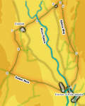
 This relatively low level walk takes us around a quiet part of Ribblesdale, to the north of Horton, touching more populated paths on three occasions (once at the start when it overlaps with the Pennine Way and twice when it joins the Three Peaks route. The walk takes in some typical limestone scenery, passing across smooth grassy shelves in the hills, past sudden ravines and across limestone pavements, and offers good views of all three of the three peaks at different stages of the walk.
Ascent: 1070ft
Length: 9.2 miles
Map:
Map: Yorkshire Dales - Southern and Western Areas (OS Explorer Map Active)
Last Walked: 10 May 2008
1 (SD 807 726)
We start facing the Crown Inn at the northern end of Horton-in-Ribblesdale. The Pennine Way leaves Horton on a track just to the right of the pub. Take this track and follow it for just over the next mile.
2 (SD 811 743)
We stay on this track until just after it crossed the valley of Self Gill Beck. At this point the track splits in two. The Pennine Way takes the right hand track, heading on up the hillside, while we take the left hand track. After a very short distance a stile crosses the wall to the left. This stile brings us to the left hand side of a ruined building. Head straight ahead to a gap in the wall, then turn right, past the ruined building, and head north along a shelf of grass on the side of the hills, with a line of limestone outcroppings to the right.
3 (SD 803 768)
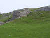
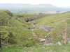 We follow the path along this level shelf for the next mile and three quarters, until our way is blocked by the deep ravine of an apparently un-named stream. The original path dropped down into this ravine, but erosion has removed that option, and the path now takes a diversion around the upper end of the ravine, which soon brings us to the continuation of the grassy shelf on the far side of the ravine.
According to the OS map the path now veers a little to the right, and climbs up the rocky outcroppings to the right of the shelf, but in practice the path continues along the grassy shelf until it is blocked by a stone wall running along the southern side of a wood-filled ravine. Turn right and climb up alongside this wall until it joins a very popular path - here we follow the Three Peaks route for a few feet.
4 (SD 803 771)
This path passes around the head of the ravine, crosses the next field and then meets a farm track. Here the Three Peak walkers continue on straight across the hills towards Whernside, while we turn left and head downhill along this track towards High Birkwith.
5 (SD 800 768)
This track soon crosses the beck in the wood-filled ravine and reaches the northern tip of the road to High Birkwith. Within a few feet of reaching this road, a stile leads into the field to the right - cross over this stile and follow the path diagonally and to the left towards a narrow band of trees. Cross over another stile to enter the trees, then a third to enter a steeply sloping field. This time head diagonally to the right across this field, heading for the right hand wall. Yet another stile crosses this wall, leading into a long narrow field with Low Birkwith Farm at the bottom end. Our path heads into the far corner of this field, passes to the right of the farm and then continues on downhill just to the left of Coppy Gill.
6 (SD 791 761)
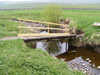
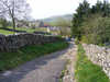
Just before we reach the River Ribble, our path turns right to cross Coppy Gill on a solid but very wonky looking bridge. We then cross the Ribble on a rather more solid looking footbridge. We are now facing a minor hill. Our path runs around the right of this hill, before reaching the start of a track at the far left corner of the field. After a short distance this track splits in two - take the right hand branch, and follow it uphill, under the railway bridge and into the hamlet of Selside.
7 (SD 784 756)
Turn right and follow the main road through Selside. At the edge of the hamlet the road climbs and curves to the left. At the end of this curve a lane leaves to the left, signposted to Alum Pot and a number of other pot holes (along with a warning that the pot holes lie on private land and instructions on how to pay for access). Turn left and follow this lane.
8 (SD 779 755)
After a quarter of a mile we reach the point where the private land begins. Here our route turns through ninety degrees to the left, and follows the public right of way as it continues along the lane.
At the end of this lane we emerge at the corner of a large field. Our track continues across this field, curving gently to the left. The track then splits in two - we need the right hand branch, which heads for a gate and stile in the far wall (the left hand branch heads towards Gill Garth Farm.
Our track continues across the next field, heading for the opposite left corner, where we pass across another stile, this time into a smaller field.
9 (SD 782 746)
A track runs from left to right across the opposite end of this field. Head for this track. Turn right onto this track, pass through a gate and follow this track into an area of access land. We now follow this track for three quarters of a mile, as it passes through two large fields. In the first of these our track climbs up steadily, across level ground, while in the second field the path is level, with limestone outcroppings to the right.
10 (SD 777 734)
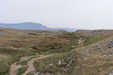 We follow this track until it crosses the main path up Ingleborough from Horton. This path is visible from the moment we enter that second field, and is almost always busy. To return to Horton turn left onto this path, and follow it along Sulber Nick, past a series of limestone pavements, and then across open fields to Horton (before doing this I recommend climbing up the slope on the far right of the crossroads in the paths - the top of this slope provides an excellent view towards Ingleborough).
This path is obvious all the way down, especially later in the day when it becomes the last leg of the Three Peaks! At the edge of the last field the path crosses the railway line (take care!). The Crown Inn and our starting point is now clearly visible along the road directly in front of the station - head down the steep station road, and then straight on along the main road back into the village.
