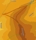

 Our second ascent of Great Whernside starts from Hunters Sleets, the area at the top of the pass between Coverdale and Wharfedale. This starting point cuts 1,000ft off the climb, and allows us to approach the summit along the northern ridge, which offers great views of Nidderdale and towards Wensleydale.
The only flaw with this route is that the area close to the road is rather wet, so be prepared for some squelching!
Ascent: 930ft
Length: 5.4 miles
Map: Yorkshire Dales - Northern and Central Areas (OS Explorer Map Active) (OS Explorer Map Active)
Last Walked:
![]() We start by the side of the road as it passes across the long flat summit of the pass. There are a number of places to park on this stretch of road, but we are going to assume that you have parked at the largest of these areas, at the top of the climb up from Wharfedale. Two main paths lead east across the grass
We start by the side of the road as it passes across the long flat summit of the pass. There are a number of places to park on this stretch of road, but we are going to assume that you have parked at the largest of these areas, at the top of the climb up from Wharfedale. Two main paths lead east across the grass ![]() towards Great Whernside - one heads right, running close to Tor Dike and the drop down to Wharfedale, while the other heads off to the left, heading towards the left hand side of the massive bulk of the mountain.
towards Great Whernside - one heads right, running close to Tor Dike and the drop down to Wharfedale, while the other heads off to the left, heading towards the left hand side of the massive bulk of the mountain.
Take this left hand route, and follow it across the grass to a wall that runs parallel to the road. A gate passes through this wall at the tip of a shallow "V". Pass through this gate, and then follow the path as it heads left, climbing gently up the lower slopes of Great Whernside. Our path is marked by a series of posts set into the hillside, and is fairly clear all the way to the ridge line. This path runs north east below the steepest parts of the western slopes of Great Whernside, which we bypass to the north.
About a mile and a third after passing through the gate our path finally reaches the ridge line that joins Little Whernside and Great Whernside, passing through a wall that runs along this ridge.
![]() From this vantage point Little Whernside is a very tempting diversion, but both the drop down into the gap between the two hills and the climb up Little Whernside are bigger than they first appear, and the ground is universally swampy, making it a rather unpleasant walk, which adds nearly three miles and over 350 feet of ascent to the walk (we tried it and I don't recommend it).
From this vantage point Little Whernside is a very tempting diversion, but both the drop down into the gap between the two hills and the climb up Little Whernside are bigger than they first appear, and the ground is universally swampy, making it a rather unpleasant walk, which adds nearly three miles and over 350 feet of ascent to the walk (we tried it and I don't recommend it).
![]() Instead turn right after passing through the gate in the wall, and follow the path as it climbs up the northern edge of Great Whernside. This is quite a steep pull - half of the total climbing on the walk comes in the next half a mile, but the reward for this climb is a fantastic ridge walk that only gains 200 feet in a mile and a half on the way to the summit.
Instead turn right after passing through the gate in the wall, and follow the path as it climbs up the northern edge of Great Whernside. This is quite a steep pull - half of the total climbing on the walk comes in the next half a mile, but the reward for this climb is a fantastic ridge walk that only gains 200 feet in a mile and a half on the way to the summit.