
Introduction
![]() Cogra Moss sits at the heart of a perfect minature mountain landscape, with water, mountains and forests all present, just on a smaller scale. The tarn is surrounded on three sides by fells, with Black Fell to the east the highest, and most dominant, while Knock Murton is most visible from the roads of west Cumbria.
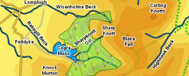
Cogra Moss sits at the heart of a perfect minature mountain landscape, with water, mountains and forests all present, just on a smaller scale. The tarn is surrounded on three sides by fells, with Black Fell to the east the highest, and most dominant, while Knock Murton is most visible from the roads of west Cumbria.
Cogra Moss was created in c.1880 by the damming of Rakegill Beck, turning a swampy valley bottom into an attractive reservoir. The lake was used as a water supply until 1975. It has a surface area of 40 acres, and is very shallow (you will notice fishermen standing some way out into the water).
The lake is now a fishery, run by the Cockermouth Angling Association. It is used for fly fishing, with Brown Trout and Rainbow Trout to be found.
There are plenty of paths and tracks through the forests around Cogra Moss, and also a really nice route up Blake Fell (see our walks section). The Forestry Commission woods cover around 160ha.
Statistics
![]() Grid Reference of centre: NY 095 195
Grid Reference of centre: NY 095 195
Altitude: 740ft
Map
How to Reach
![]() Cogra Moss can be reached from a small car park at Felldyke - follow the track east from the village, which runs across the middle of a field before dropping down towards the lake.
Cogra Moss can be reached from a small car park at Felldyke - follow the track east from the village, which runs across the middle of a field before dropping down towards the lake.
Walks
Our ascent of Blake Fell visits Cogra Moss.
Inflows
Three becks flow into Cogra Moss. A short nameless beck rises between High Hows and Sharp Knott and flows into the northern side of the tarn.
Sharpknott Gill rises on the south-western side of Sharp Knott and flows south-west to flow into the eastern tip of the tarn.
Finally a beck rises between Blake Fell and High Pen and flows west to run into the tarn just to the south of Sharpknott Gill.
Outflow
Rakegill Beck flows west out of Corga Moss.
Other Features
Other Features