
Introduction
Lingmell is somewhat overshadowed by its position next to Scafell Pike, but it is a remarkably fine fell in its own right and on a busy day its summit can be a rare oasis of calm in this busy area. The fell takes the form of a long wedge rising up from Wasdale Head to its rocky summit, ![]() before plunging down its eastern crags into the fearsome ravine of Piers Gill. The northern and southern slopes are largely grassy with the odd outbreak of rock, and are distinguished by their smooth steepness. These two slopes come together
before plunging down its eastern crags into the fearsome ravine of Piers Gill. The northern and southern slopes are largely grassy with the odd outbreak of rock, and are distinguished by their smooth steepness. These two slopes come together ![]() at the western end of the fell to form the long steep ridge that climbs up from the eastern end of Wast Water.
at the western end of the fell to form the long steep ridge that climbs up from the eastern end of Wast Water.
At the top of the steep slopes the fell levels out and there is a large grassy plateau which rises up gently towards Goat Crags. These sit at the western end of the rocky upper reaches of the fell, which rises up another 150 meters from the top of the plateau before the summit is reached.
Statistics
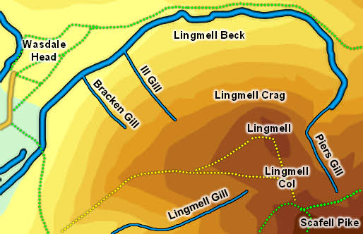
Grid Reference of Summit: NY 209 081
Height: 2,649ft
Map
Routes of Ascent
There two main routes onto the summit of Lingmell. The northern and eastern slopes of the fell are too steep to be climbed. as is most of the slope above Lingmell Gill, although this slope does even out nearer the top (see below).
There is one direct route from the valley bottom to the summit, taking the long path up the steep western ridge. This emerges onto a wider plateau with Goat Crags seen ahead - when the path across this plateau splits take the left-hand branch, which eventually reaches the summit (the right-hand path heads across the plateau and makes for Scafell Pike.
![]() The second route comes from Lingmell Col, the pass to Scafell Pike. The Col can be reached from either the main tourist path up Scafell Pike via Hollowstones or via the Corridor Route from Sty Head. In both cases these paths miss the col itself, as they are both heading for Scafell Pike. However its an easy walk to drop down to the Col. The col is fairly pathless, but a clear path starts at the foot of climb up to the summit of Lingmell.
The second route comes from Lingmell Col, the pass to Scafell Pike. The Col can be reached from either the main tourist path up Scafell Pike via Hollowstones or via the Corridor Route from Sty Head. In both cases these paths miss the col itself, as they are both heading for Scafell Pike. However its an easy walk to drop down to the Col. The col is fairly pathless, but a clear path starts at the foot of climb up to the summit of Lingmell.
Finally the slopes between Hollow Stones and the summit are fairly gentle, so the tourist path could be left when you are south of Goat Crags and a fairly direct route taken north-east towards the summit of Lingmell.
Walks
We currently have one ascent of Lingmell - Lingmell via the Corridor Route
The Summit
![]() The final summit sits on a rocky outcropping that runs north-south across the top of the fell. The unwary walking coming up the western ridge will encounter two false summits - first the top of the ridge itself, which looks like a peak from below but is simple the edge of the large plateau, and then Goat Crags, which hide the true summit.
The final summit sits on a rocky outcropping that runs north-south across the top of the fell. The unwary walking coming up the western ridge will encounter two false summits - first the top of the ridge itself, which looks like a peak from below but is simple the edge of the large plateau, and then Goat Crags, which hide the true summit.
The summit sits right over the cliffs above Piers Gill, so there are very dramatic views off to the east, looking across the route taken by the Corridor Route towards Great End. There are also super views of the top of Scafell Pike and the final stretches of the tourist path. The views into Wasdale aren't quite as good from the highest point, but head north towards Lingmell Crags to get the best views down into the upper reachs of Wasdale. The best views of Wasdale Head come from the western ridge.
Streams and Tarns
Lingmell is bordered by notable streams on all sides, although one tends to dry up with surprising ease. To the east is the dramatic run of Piers Gill, which is born in the northern slopes of Scafell Pike and then runs south past the eastern side of Lingmell before joining Lingmell Beck.
To the south Lingmell Gill down the valley between the fell and Scafell, after emerging below the western crags of Scafell Pike. The lower stages of the Hollowstones path run to the north of the gill, before crossing it to reach Brown Tongue. After heavy rain this crossing can be quite awkward.
![]() The most interesting of the three is Lingmell Beck, which runs down from the western side of Sty Head, and is the main stream in the upper reaches of Wasdale, forming the boundary between Great Gable and Lingmell. Any one has struggled to cross this steam while taking the valley bottom path up to Sty Head will be astonished to discover that it almost always disappears underground before it reaches the western slopes of Lingmell. A bridge crosses the dry steam bed on the path from Wasdale Head to Lingmell. Having explored this dry stream bed the water was found to disappear into its gravel bed as it curves around the north-western corner of the fell. Some of it re-emerges in the wet fields to the west of the stream bed, and the water returns to its normal bed just to the west of the footpath that links the NT car park and camp site to Wasdale Head. Only after very heavy rain does the water return to this part of the stream bed.
The most interesting of the three is Lingmell Beck, which runs down from the western side of Sty Head, and is the main stream in the upper reaches of Wasdale, forming the boundary between Great Gable and Lingmell. Any one has struggled to cross this steam while taking the valley bottom path up to Sty Head will be astonished to discover that it almost always disappears underground before it reaches the western slopes of Lingmell. A bridge crosses the dry steam bed on the path from Wasdale Head to Lingmell. Having explored this dry stream bed the water was found to disappear into its gravel bed as it curves around the north-western corner of the fell. Some of it re-emerges in the wet fields to the west of the stream bed, and the water returns to its normal bed just to the west of the footpath that links the NT car park and camp site to Wasdale Head. Only after very heavy rain does the water return to this part of the stream bed.
One minor beck runs down the southern slopes of the western ridge to join Lingmell Gill.
Several minor becks run down the northern slopes to feed Lingmell Beck (many more after dry weather). Bracken Gill and Ill Gill have earnt names.
Lingmell has no tarns.
Other Features
The summit sits right above Piers Gill, which for a time runs parallel to eastern edge of the cliffs, so there is a great but rather alarming view straight down the cliffs and into the looming chasm below.