 This short walk takes us up onto Whin Rigg, one of the two summits perched above the Wasdale Screes. Whin Rigg offers one of the best views of Wastwater, a full length view along the screes, as well as a good view of Sca Fell.
Ascent: 1,600ft
Length: 2.5 miles
We start from the road side parking in the area where the two roads into Wasdale meet at the southern end of the lake.
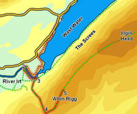
1: NY 150 054
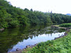
From the road junction head south along the road to Nether Wasdale, until it turns right and moves away from the lake shore. At this point a permissive footpath continues on along the lakefront. Take this path and follow it as it runs through a series of fields, then in front of the Wasdale Youth Hostel. Just past the hostel the path follows the lake shore as it curves around to the left. We then follow this path around Low Wood, past the last few feet of Wastwater and onto the River Irt.
2: NY 141 039
Just before the path emerges from Low Wood we reach a bridge across the river. Cross this bridge, turn left and retrace your steps alongside the Irt. This path takes us through one large field and a short section of woodland, before reaching joining a larger track.
3: NY 143 037
Turn right onto this track, and follow it west. After a short distance a signposted footpath leaves to the left, heading across a rough field and then climbing steeply up the side of Whin Rigg, with Greathall Gill to the right.
4: NY 145 027

Follow this path until it begins to level out. At this point the path branches. The left-hand branch is a short-cut to the summit, but the right-hand branch takes us to the top of the ravine carved by Greathall Gill, so take this path. At the top of the path turn left onto the path than runs along the ridge line all the way to the summit.
5: NY 151 034
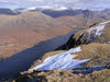 Although Whin Rigg has a small summit, there are several different viewpoints worth visiting. The best known is marked by a small cairn, and looks down onto the screes and Wast Water (take care here, as the cliffs are close to the summit). It is also worth heading a little way across the summit in the opposite direction (south-east), to reach the best viewpoint for Miterdale and Burnmoor Tarn.
After exploring the summit retrace your steps back to the starting point.
