 This short walk brings us to Tarn Hows from a different direction, and may be useful during busy periods when the main car park and its approach roads can be very crowded.
Ascent: 365ft
Length: 1 miles
Map: The English Lakes - South Eastern Area (OS Explorer Map Active)
Last Walked:
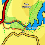
We start from the National Trust car park just to the south of Yew Tree Tarn on the A 593.
At step two and three we will give the directions for the direct route, but we recommend spending more time exploring the paths around Tarn Hows.
1: SD 321 999
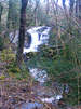
Two paths leave the car park. On this walk we will use the path that runs alongside Tom Gill to reach the Tarn and return on the second path. From the car park face the road and turn right to face towards Tom Gill. A clear well signposted path climbs up through the woods, with the stream to the right. This path passes Tom Gill Falls, before reaching the edge of Tarn Hows just to the left of the dam that keeps the water in place.
2: SD 327 997
Turn right onto the lake shore path and follow it across the dam. Just after the dam the path splits - take the right-hand branch which climbs up away from the water, with the trees to the right and open ground to the left.
3: SD 326 996
After a short distance turn right onto a track that soon begins to drop down the hill side. Follow this track as it zig-zags down the hill.
4: SD 321 997
This track eventually reaches a T-junction with a second track. Turn right onto this track and follow it back to the car park.
