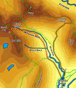
 This alternative version of the Mosedale Horseshoe avoids the dreadful scramble up to Dore Head, and instead takes us up to the very end of Mosedale, a delightful walk on grass between the crags of Red Pike and Pillar. After that it is possible to visit the summits of Red Pike and Scoat Fell for very little effort, before moving on to Pillar itself, before returning via Black Sail Pass.
Ascent: 3,500ft
Length: 8 miles
Maps: The English Lakes - North Western Area (OS Explorer Map Active)  and Map: The English Lakes - South Western Area (OS Explorer Map Active)
Last Walked:
We start in the car park at the Wasdale Head Hotel. If this is full use the village green car park and walk up the lane to the hotel.
1: NY 186 087
Buildings line two sides of the car park, with the Hotel on one side and a walking shop (The Barn Door) on another. Head into the gap between the two sets of buildings. This brings us up to Mosedale Beck, which runs behind the hotel. Turn right, and head upstream towards a simple pack horse bridge that crosses the beck. Cross this bridge, then follow a track that heads off diagonally to the right, running between two stone walls. Follow this track as it climbs up alongside Mosedale Beck, past a series of waterfalls, and into the heart of Mosedale.
2: NY 179 098
 We follow this path as it runs around the left-hand side of the flat base of Mosedale. The tradition start for the Mosedale Horseshoe climbs up Dorehead Screes, to our left, but this is an unpleasant scramble up a long scree slope or on steep grass, so we will ignore it. Look out for a sheepfold just past the point where the main path heads up the slope to the left. A clear path runs through this sheepfold and continues up the valley, with Mosedale Beck to the right.
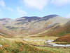
 Our path remains clear for some way, crossing the wall beyond Black Beck via a modern stile, but soon after that it begins to fade away. Continue to head up Mosedale, keeping Mosedale Beck close to the right, taking advantage of a long grassy slope that takes us into the upper reaches of the valley, surrounded by crags and scree slopes, and with a wall of crags on the skyline.
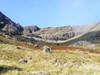
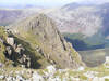
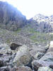 Our route to the top is actually visible from some distance. A boulder field on the left of the valley leads up to a small gully that climbs up a gap in the crags and connects the valley with the grassy slopes above. This gully could be reached by climbing up the boulder field, but an easier route is to follow the grassy slopes around Mosedale Beck as far as possible, curving around to the right of a isolated crag. Once past this crag take advantage of another grassy slope to climb back up to the left-hand side of the valley and the approach to the gully.
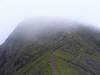
The passage through the gully itself is a simple twenty-feet long scramble. Once at the top of the gully continue up the grassy slope beyond until you reach the path that connected Wasdale Red Pike with Scoat Fell.
3: NY 162 110
Having reached this point, it is well worth making a quick diversion to the top of Red Pike, which is only ten minutes away to the left before heading up Scoat Fell. To reach the top of Scoat Fell head straight up the side of Scoat Fell, head towards the highest point on the skyline to the north-west. Although this is a right of way, no path exists on the ground - the path from Red Pike curves away to the right on its way to Pillar, and ignores Scoat Fell, but we will not.
4: NY 159 113
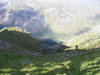
The easy climb up the slopes of Scoat Fell soon brings us to the long summit, divided in two by a stone wall, with the cairn perched on top! Cross the wall, and then turn left to reach the best viewpoints across to Steeple, then turn back, re-cross the wall and head east along the summit, with
the wall to your left, until this path joins up with the path from Red Pike. After that follow the combined path along the un-named summit between Scoat Fell and Pillar, and down into Wind Gap. From here a clear path climbs up the south-western flank of Pillar, soon reaching the summit plateau, with its collection of wind shelters, cairns and a trig-point.
5: NY 171 121
To continue on, turn right at the trig-point (in foggy weather look for a fence post that marks the route). This path follows the eastern ridge of Pillar, with crags to the left, and the slope that leads down into Mosedale to the right. We loose altitude in a series of steps. The first starts close to the
summit and brings us to a flatter area above Pillar Cover. The second brings us down to a longer
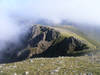
flatter area, with a choice of two routes - the main path, which runs along the centre of the plateau, or the route of the fence, which offers much better views into Ennerdale. I recommend the fence route. The two paths rejoin for the next drop, the steepest of the three. This brings us down to Looking Stead, a small grassy summit just to the left of the main path. Take the time to visit Looking Stead, which is a very pleasant place to sit and look at Pillar's crags. After that continue on down the slope to the top of Black Sail Pass.
6: NY 191 114
At the top of the pass turn right and follow the footpath that runs down the pass, and back into Mosedale. Once in the valley our path curves to the left, running around the foot of
Kirk Fell, on the opposite side of the valley to our original path.
7: NY 187 090
We follow this path until it reaches a T-junction back in Wasdale. Here turn right, still with Mosedale Beck to our right, and follow the path alongside the beck all the way back to the Hotel and our starting point.
