
 This walk combines sweeping views from some of the highest parts of the Wolds with a walk through Millington Pastures, one of the few areas of access land in the Yorkshire Wolds, and the option of a walk through Millington Woods, one of the very few wooded (non-conifer) valleys left in the area.
Ascent: 1,200ft/ 380m
Length: 8.5 miles/ 14km
Map: Explorer 294 Market Weighton Yorkshire Wolds Central
Last Walked: 27 March 2007
We begin from the car park at Millington Wood, on the road that leaves the village of Millington heading north along Millington Dale.
 We are now at the southern end of a long narrow field. Turn slightly to the left and head up this field, aiming for the highest point on the skyline - our target is the northern tip of the field.
 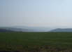 After about a quarter of a mile we reach a junction in the road (just past Millington Grange). Take the right hand branch.
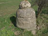 We follow this road north for the next mile and a quarter, passing that quarry, until we reach a crossroads, marked by some rather unusual gate posts. At this crossroads turn right.
 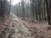 We follow this next road for about a mile as it curves around the northern edge of Greenwick Dale (to the right). Just before our turn, a side road joins this road from the left. Just after this turn right onto a track that leads down a wooded valley to the right.
Soon after we enter the woods, a footpath leaves the track to the right, heading down the valley (while the track curves around to the left, staying high in the trees). Turn right onto the path and follow it down hill. After a short distance this path emerges from the woods into a patch of open ground. The path runs across this field, and then re-enters the trees, still following the line of this valley.
 After a short patch in the trees, our path joins the track running down Greenwick Dale and Tun Dale. To the right the track soon disappears around a corner, but to the left we can see a long way down this track as it runs straight down the valley. Turn left and follow this straight path.
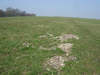
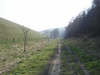
 We follow this track all the way back to the road, passing through Millington Pastures on the way. After a short distance the trees to the left end, but the trees to the right continue almost to the end of this first straight segment. Just past the end of those trees a side-valley joins from the left, but the only path follows the main dale (now Frendal Dale) to the right. We then follow the path as it curves its way through the pastures all the way to the road.
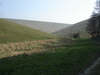
 This path along is interrupted by two side valleys, Nettle Dale and Sylvan Dale. Follow the path as it dips down into Nettle Dale, and then climb back up the opposite side the valley, still keeping Millington Dale and the road to the right. On the way down into Nettle Dale we join the Wolds Way, and on the way out the Minster Way, so this next stage of the path is on two long distance paths.
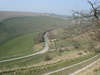
 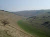 We follow this path along the top of the hill for about half a mile, with farmland to the left and a grassy slope running down into the dale to the right. We then emerge at the top of the northern slopes of Sylvan Dale. A rather alarming path drops down into this dale - this is our route onwards, and is not as bad as it looks from the top - if this path does not
 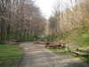 appeal, it is possible to avoid it by zigzagging to the left.
At the bottom of Sylvan Dale turn right and follow the path back to the road. At the road turn left and follow it all the way back to Millington Wood. If you have the time (and the energy) then it is well worth following the path that leads up into Millington Wood, ending at a great viewpoint on the far slopes.