
 This walk takes us along the southern shores of Loweswater, passing through Holme Wood, a good place to spot both deer and red squirrels, before returning along a hillside terrace that offers fantastic views towards Whiteside and Grasmoor.
Ascent: 880ft
Length: 5.3 miles
Map: The English Lakes - North Western Area (OS Explorer Map Active) (OS Explorer Map Active)
Last Walked: Spring 2010
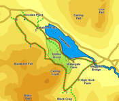
We start in the National Trust car park at Maggie's Bridge. This is not signposted from the road that runs alongside Loweswater, but can be found by turning right onto the first road after the lake (when heading south), signposted as a bridle way, or by taking the second left after the phone box when heading north (not including the turn at the phone box).
![]() At the farm we can either follow the track as it passes the farm and then turned right, or cut across the grass to the right. In either case this brings us to the edge of Holme Wood. Follow the track as it runs into the woods. After a short distance a path leaves to the right, running along the lake shore. Follow this track, which passes the small National Trust bothy (available as a holiday let).
At the farm we can either follow the track as it passes the farm and then turned right, or cut across the grass to the right. In either case this brings us to the edge of Holme Wood. Follow the track as it runs into the woods. After a short distance a path leaves to the right, running along the lake shore. Follow this track, which passes the small National Trust bothy (available as a holiday let).
Just before we reach the far end of the wood this path brings us back to the track - turn right and follow it out of the wood, and through the next few fields to Hudson Place.
![]() At first this track runs along the boundary between smaller improved fields to the left and larger wilder fields to the right. After just over a third of a mile it begins to climb more steeply, following the line of a stone wall (to the left). After about a quarter of a mile the track passes through a gate (where the wall swaps from the left to right hand side of the track).
At first this track runs along the boundary between smaller improved fields to the left and larger wilder fields to the right. After just over a third of a mile it begins to climb more steeply, following the line of a stone wall (to the left). After about a quarter of a mile the track passes through a gate (where the wall swaps from the left to right hand side of the track).
Here the track turns left and splits in two. Take the clearer left-hand track, which soon leads us onto a terrace that runs along the lower slopes of Burnbank Fell and Carling Knott, with Holme Wood to the left. Follow this track as it runs along the entire southern flank of the wood, and then drops down towards Highnook Beck