
 This is a long strenuous walk that deserves to have a full day devoted to it, but the reward is an unusual approach to the Langdale Pikes, combined with some great views over Grasmere and Rydal Water.
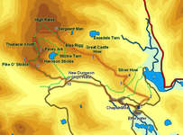
This walk is going to have less precise instructions than most of our walks for two reasons. A number of paths run up the ridge that runs from Silver How to Sergeant Man, all of which end up at the same place, so general advice is more useful than overly prescriptive instructions. Once at Sergeant Man there are a number of different possible objectives - I can tell you what I did, but that doesn't mean that you need to pick the same pikes to visit.
Ascent: 3,000ft
Length: 11 miles
Maps: The English Lakes - South Western Area (OS Explorer Map Active) (OS Explorer Map Active) and The English Lakes - South Eastern Area (OS Explorer Map Active) (OS Explorer Map Active)
Last Walked:
We start at the free National Trust car park just north of the main road at Elterwater
![]() This path climbs up to a dip between the end of Huntingstile Crag and a minor rise. Just as the path reaches the level ground in this dip, a clear path branches off to the left, and begins to climb up the slope to the west, passing to the right of the main crag.
This path climbs up to a dip between the end of Huntingstile Crag and a minor rise. Just as the path reaches the level ground in this dip, a clear path branches off to the left, and begins to climb up the slope to the west, passing to the right of the main crag.
![]() This is the start of the path that climbs all the way to Sergeant Man, but for the moment we are only going to stay on it for just under one mile. The path reaches the top of Huntingstile Crag, then climbs gently up the ridge towards Dow Bank. From the top of Dow Bank the path then drops down again, crossing over a path that runs across the ridge, then climbs up to the top of Spedding Crag.
This is the start of the path that climbs all the way to Sergeant Man, but for the moment we are only going to stay on it for just under one mile. The path reaches the top of Huntingstile Crag, then climbs gently up the ridge towards Dow Bank. From the top of Dow Bank the path then drops down again, crossing over a path that runs across the ridge, then climbs up to the top of Spedding Crag.
We can now see our first target - the summit of Silver How, off to the right. For the moment we continue along our current path, heading to the left of the bulk of Silver How.
![]() Our route onwards is clearly visible from the summit of Silver How - a long ridge, punctuated by a series of crags, leads up to Sergeant Man, which is visible as a slight bump on the skyline, separated from the bulk of the Langdale Pikes by a long smooth dip.
Our route onwards is clearly visible from the summit of Silver How - a long ridge, punctuated by a series of crags, leads up to Sergeant Man, which is visible as a slight bump on the skyline, separated from the bulk of the Langdale Pikes by a long smooth dip.
![]() We begin our trip from Silver How to Sergeant Man by following one of the paths that lead south west off the summit, down into the slight dip between Silver How and Lang How. Our path passes just to the left of Lang How, but then for the next mile and a half our aim is to pass over or close to the tops of Swinescar Pike, Little Castle How and Great Castle How. A network of paths run along the top of this ridge, especially over Little and Great Castle How, although the main path is actually fairly clear.
We begin our trip from Silver How to Sergeant Man by following one of the paths that lead south west off the summit, down into the slight dip between Silver How and Lang How. Our path passes just to the left of Lang How, but then for the next mile and a half our aim is to pass over or close to the tops of Swinescar Pike, Little Castle How and Great Castle How. A network of paths run along the top of this ridge, especially over Little and Great Castle How, although the main path is actually fairly clear.
 From the top of Castle How onwards the path is much clearer, running onto Blea Rigg, and then up the final steep part of the ridge to Sergeant Man. The ridge actually reaches the High Raise plateau just to the right of Sergeant Man, before turning to the left to climb up onto this rocky viewpoint.
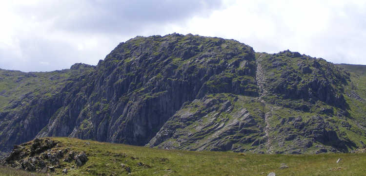
 ![]() Pavey Ark is best known for the dramatic cliffs that tower above Stickle Tarn, but the summit area is also of interest, made up of a series of gigantic rocky slabs.
Pavey Ark is best known for the dramatic cliffs that tower above Stickle Tarn, but the summit area is also of interest, made up of a series of gigantic rocky slabs.
![]() From Pavey Ark a clear path continues south towards Harrison Stickle, running just to the right of the rocky summit of that pike. Follow this path up to a crossroads where it crosses the path from Thunacar Knott to Harrison Stickle.
From Pavey Ark a clear path continues south towards Harrison Stickle, running just to the right of the rocky summit of that pike. Follow this path up to a crossroads where it crosses the path from Thunacar Knott to Harrison Stickle.
If you wish to visit the top of Harrison Stickle, then turn left at this crossroads and follow the path up to the highest of the Langdale Pikes.
On this particular walk I chose to bypass Harrison Stickle and head for Pike of Stickle, on the far side of Harrison Combe. Ignore the first crossroads, and follow the path until it begins to drop down into the combe. At the next junction turn right and follow the path that runs straight from Harrison Stickle to Pike of Stickle.
![]() Pike of Stickle is not for the nervous. The summit is surrounded by crags on all sides, with the only safe access on the side facing north towards Harrison Combe. A path curves up around the Pike, but don't follow it too far. Instead, soon after reaching the top of a flight of steps built into the path look for the easiest route to scramble up to the top.
Pike of Stickle is not for the nervous. The summit is surrounded by crags on all sides, with the only safe access on the side facing north towards Harrison Combe. A path curves up around the Pike, but don't follow it too far. Instead, soon after reaching the top of a flight of steps built into the path look for the easiest route to scramble up to the top.
Be careful on the summit itself - the safe area is very small and is surround by crags - don't even think about visiting if visibility is poor. Return to the path by retracing your steps (or scrambles) down the northern face of the Pike.
At the base of Pike of Stickle turn right and follow the clear path that towards Loft Crag, staying on the ridge to the south of Dungeon Ghyll.
Just before the end of this ridge, our path turns right and begins to descend rapidly down the southern flank of the Langdale Pikes. This path is clear and well constructed all the way down to the Old Dungeon Ghyll hotel. The first part drops down to the south, then curves around to the left to reach a level grassy area below Thorn Crag. It then turns to the right, passing down Mark Gate, and curving around to the left, running past Dungeon Ghyll Force.
Just after passing the Force, the path crosses the Ghyll and reaches a T-junction. Turn right, and follow this path down hill to another T-junction. This time turn left, and follow the path as it runs down to the Dungeon Ghyll Hotel.