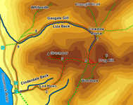
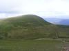
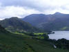
 This walk takes us up Grasmoor, using the best line of approach on the southern face, up the ridge from Lad Hows. This is a steep climb up a good path, with useful zigzags at the steepest moments, and gives fantastic views of the massive south face of the mountain and the upper reaches of Rannerdale.
From Grasmoor we then head east to Crag Hill, which in some ways is a better viewpoint than Grasmoor.
We return via Coledale Hause and Gasgale Gill, where the Liza Beck runs through a quiet isolated valley between Gasgale Crags on the southern slopes of Whiteside and Dove Crags on Grasmoor.
Ascent: 2,930ft
Length: 6.7 miles
Map: The English Lakes - North Western Area (OS Explorer Map Active)
Last Walked: 21 August 2009
There are several car parks on the shores of Crummock Water. We start from the car park next to Cinderdale Beck, at the entrance to Rannerdale.
1: NY 162 192
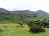
A faint but distinct lane leaves the car park, and the curves right to cross Cinderdale Beck. Cross over here, and then turn left onto a path that climbs up the fell with the beck to its left. There are several paths on the lower part of the fell, but they soon merge into a single path that winds its way up around a series of crags onto Lad Hows
2: NY 172 193
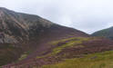
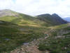
From the top of Lad Hows the path up onto Grasmoor comes more clearly into sight. Follow this path as it climbs increasingly steeply up onto the large grassy summit plateau.
3: NY 177 203
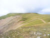
Just after the top of the steepest part of the climb our path joins the main summit path across Grasmoor. Turn left and follow this path to the highest point on the fell, marked by a well designed wind shelter. Take the time to explore the top of the fell - the wide grassy plateau means that the best viewpoints are rather scattered (be careful in the mist - the top of Dove Crags isn't too far to the north).
4: NY 174 203
After exploring the top head back east across the summit plateau. At first the path runs gently downhill, offering an excellent view of the
Helvellyn range on a clear day, before dropping more steeply down.
5: NY 186 201
The path drops down the eastern flag of Grasmoor to reach a crossroads in the path at an unnamed mountain pass. Our route onwards leads straight across this junction to climb up the relatively gentle slope that leads to the top of
Crag Hill (if you decide to skip this extra climb then turn left instead, and skip to step 7).
6: NY 192 203
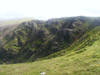
After admiring the view from Crag Hill (also known as Eel Crag), turn back and follow the same path back towards the crossroads. At the crossroads turn right (north), and follow the upper stages of the Liza Beck as it runs down towards Coledale Hause (it is possible to cut this corner a little after the steepest segment of the path down from Crag Hill).
7: NY 188 210
 Follow this path all the way down to Coledale Hause. Just before the hause there is a junction in the path, where the path down Gasgale Gill branches off to the left. Ignore this path for the moment, and continue on to the top of the hause to take advantage of the excellent view down Coledale. After that turn left to follow the faint path that cuts across to the Gasgale path.
 The path down Gasgale falls into three distinct segments. In the first section a rocky path drops quite steeply down alongside the beck. This then leads into the heart of the valley, where the path is smoother. This is the longest section, and lasts until we reach the only clear junction in the valley
8: NY 168 211
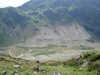
The third section of the valley bottom path follows the stream as it runs past a series of crags that almost reach the water. This path is passable, but only just in places. If you don't mind the odd scramble then stick with the riverside path. If not, then take the path that branches off to the right just before the first riverside crag, running level across the slopes of Whiteside. After about a third of a mile this path reaches a path climbing up Whiteside - turn left and follow this path back down to the side of the beck.
9: NY 162 209
Eventually the path emerges from the valley onto the lower slopes of Grasmoor. Take advantage of the first footbridge to cross the Liza Beck, and then look out for a path that curves away to the south, running across the lower slopes of the mountain. Follow this path as it runs all the way back to our starting point.
