
 This is a lengthy walk in some of the most impressive mountain scenery at the head of Borrowdale, visiting Sty Head and Sprinkling Tarn before finally turning north to climb up to the summit of Glaramara, in a dominating position in the heart of Borrowdale.
Ascent: 2,800ft
Length: 9.5 miles
Maps: The English Lakes - South Western Area (OS Explorer Map Active) and The English Lakes - North Western Area (OS Explorer Map Active)
Last Walked:
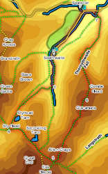
We start from the National Trust car park at Seatoller.
![]() Follow this path up to Stockley Bridge. Cross Grains Gill using this bridge, then follow the path that climbs straight up the fellside opposite the bridge, passing to the left of Taylorgill Force (this route takes us to Styhead - for a shorter route turn left after crossing the bridge, and follow the path alongside Grains Gill all the way to the foot of the crags of Great End, turn left onto the busy footpath to the false Esk Hause and follow it to step 5).
Follow this path up to Stockley Bridge. Cross Grains Gill using this bridge, then follow the path that climbs straight up the fellside opposite the bridge, passing to the left of Taylorgill Force (this route takes us to Styhead - for a shorter route turn left after crossing the bridge, and follow the path alongside Grains Gill all the way to the foot of the crags of Great End, turn left onto the busy footpath to the false Esk Hause and follow it to step 5).
Our main route passes Taylorgill Force, and then follows Styhead Gill up to Styhead Tarn and Sty Head.
![]() Although a multitude of paths run across Sty Head, our route is fairly straight forward. Follow our current path to the top of the pass and the first aid box. Turn left here onto the path that runs across the top of the pass, crossing some very wet ground on stepping stones, and continue to follow this path as it climbs up a flight of steps running alongside a beck in an impressive ravine.
Although a multitude of paths run across Sty Head, our route is fairly straight forward. Follow our current path to the top of the pass and the first aid box. Turn left here onto the path that runs across the top of the pass, crossing some very wet ground on stepping stones, and continue to follow this path as it climbs up a flight of steps running alongside a beck in an impressive ravine.
This path soon brings us to Sprinkling Tarn (it is well worth taking the time to explore this tarn). From Sprinkling Tarn it climbs over a small rise, before dropping down to pass across the head of Ruddy Gill. When the gill reaches the path it turns left, and runs alongside our path in a very impressive ravine. Towards the end of this ravine the path splits. Our route is the left-hand path, which brings us to the false Esk Hause. The right hand branch (which we don't want!) takes us to the true Esk Hause and then on to Scafell Pike.
We are now at the False Esk Hause, a shoulder of high ground between the true Esk Hause (to the right) and Allen Crags (to the left). Turn left here and follow the path that climbs steeply up onto Allen Crags. The summit of this fell is less than 900ft from the junction, so if you aren't on top of a mountain fairly soon after leaving the false Esk Hause you are on the wrong path!
A fairly clear path now takes us along the interesting ridge that runs from Allen Crags to Glaramara. After dropping down from Allen Crags we pass a series of tarns, before climbing over a small nameless summit. This is followed by the climb around the lower southern summit of Glaramara.
![]() The higher northern summit is split into two separate tops. The first (south-western) summit is probably the highest. The path then drops down into the small dip between the two, before climbing up on the second summit. From here the main path then drops down the northern face of the summit. This route includes a rather nasty rocky step, which can be avoided in several ways. The easiest is to return to the dip between the two summits, then turn right and head down the grassy slope between the two summits. At the base of the crags turn right and follow them around to the main path.
The higher northern summit is split into two separate tops. The first (south-western) summit is probably the highest. The path then drops down into the small dip between the two, before climbing up on the second summit. From here the main path then drops down the northern face of the summit. This route includes a rather nasty rocky step, which can be avoided in several ways. The easiest is to return to the dip between the two summits, then turn right and head down the grassy slope between the two summits. At the base of the crags turn right and follow them around to the main path.
![]() We now follow this path down the long ridge of Thornywaite Fell, the eastern wall of Borrowdale between Seatoller and Seathwaite. The path tends to follow the right-hand side of this ridge, giving us some great views back towards Combe Head, which soon obscures the true summit of the fell.
We now follow this path down the long ridge of Thornywaite Fell, the eastern wall of Borrowdale between Seatoller and Seathwaite. The path tends to follow the right-hand side of this ridge, giving us some great views back towards Combe Head, which soon obscures the true summit of the fell.
Towards the bottom of the fell our path comes close to Combe Gill, before turning gently away to the left as it runs through some open woodland.