
Introduction
Moss Dub is a small man-made tarn in the Ennerdale valley, created by blasting out the ground in a naturally wet hollow just to the south of the River Liza.
![]() The tarn shows up on the 1945 New Popular Series of maps and the 1933 Land Utilisation Survey of Britain. The name is much older, and 'Moss Dub' was mentioned in the Ennerdale Railway Bill of 1884, when it would have been near the eastern end of the proposed railway.
The tarn shows up on the 1945 New Popular Series of maps and the 1933 Land Utilisation Survey of Britain. The name is much older, and 'Moss Dub' was mentioned in the Ennerdale Railway Bill of 1884, when it would have been near the eastern end of the proposed railway.
In the 1970s efforts were made to make it suitable for wildfowl, including the use of explosives to deepen the pool, but ducks and similar birds are now very rarely seen on the tarn.
The tarn is entirely surrounded by mature conifers (as of 2014). The tarn also used to be surrounded by Rhododendrons, but the Wild Ennerdale partnership is involved in a long-term effort to remove this invasive species, which tends to overwhelm native plants and can spread dangerous tree diseases.
The tarn is large enough for there still to be impressive views across the water to the surrounding fells, and in particular Pillar, which can be seen from the western shores.
Statistics
Grid Reference of centre: NY 145 137
Altitude: 450ft
Map
How to Reach
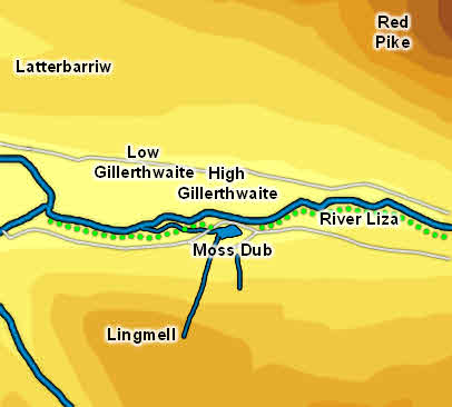
Moss Dub is located just to the north of the main forest road on the south side of Ennerdale. The nearest public road access ends at Bowness Knott. From there follow the forest track to the eastern end of the lake, then turn right to cross over Irish Bridge. Follow this track across the fields in the valley bottom, then turn left once back in the trees. The track crosses Woundell Beck over a new bridge, then comes to a gate - from here you have two choices - either the Liza Path, which leaves the track to the left of the gate and follows the river, or the forest track itself. Both bring you to the tarn.
High Gillerthwaite YHA is just across the river from the tarn, but the nearest bridge is just over a miles further west - cross this bridge, follow the footpath south-west across the open fields to the forest, then turn left to join the same route as above.
Walks
None of our walks currently visit Moss Dub.
Inflows
Moss Dub is fed by a nameless beck that flows down from Lingmell.
Outflow
Another nameless beck flows out of Moss Dub, heading west through the trees to join the River Liza. Part of the Liza Path crosses this beck just before it reaches the forest road.
Other Features
Despite its small size Moss Dubs contains at least one island, sometimes two (depending on water levels).