
Introduction
![]() Low Water sits below the eastern crags of the Old Man of Coniston and Brim Fell, which surround it on three sides. On the open, east, side, there is about 400ft of gently sloping ground, followed by a steep drop down towards the Coppermine Valley area.
Low Water sits below the eastern crags of the Old Man of Coniston and Brim Fell, which surround it on three sides. On the open, east, side, there is about 400ft of gently sloping ground, followed by a steep drop down towards the Coppermine Valley area.
The tarn has generally grassy shores, although there are more exposed rocks on the side nearest the tourist path. The tarn is now entirely natural, although in the past it has been raised by a dam to provide water for the quarries below.
Despite its name Low Water is actually located at quite a high altitude, and thus doesn't really feature in many views from the surrounding area. It can be glimpsed from the southern ridge of Wetherlam, but is best seen from above, from the Brim Fell and Old Man ridge.
Statistics
Grid Reference of centre: SD 274 982
Altitude: 1,795ft
Map
How to Reach
Low Water Tarn can be reached along the busy tourist path from Coniston to the top of the Old Man via the eastern quarries.
Walks
None of our walks visit Low Water
Inflows
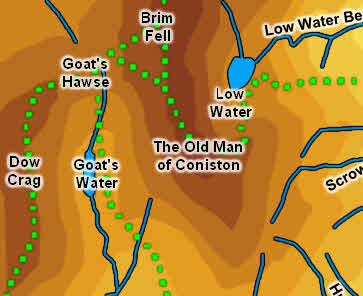
Three unnamed becks flow into Low Water, one from below the summit of the Old Man of Coniston, one rising below the summit of Brim Fell and one from the ridge that runs east towards Raven Tor.
Outflow
Low Water Beck flows east out of Low Water, drops down the step east of the tarn and flows into Levers Water Beck in the valley below.
Other Features
-