
Introduction
![]() White Side or Whiteside Bank is the next fell north along the Helvellyn Range (taking Lower Man as part of the parent fell). At over 2,700ft it would be a sizable fell in other company, but here it is rather overwhelmed by its taller and much more dramatic neighbour. However the summit is visited by more walkers than it would be in another location as it carries the shortest route up Helvellyn from the Ullswater side that doesn't involve either Striding Edge or Swirral Edge. Tbere can't be many people who climb Whiteside Bank without going on to Helvellyn.
White Side or Whiteside Bank is the next fell north along the Helvellyn Range (taking Lower Man as part of the parent fell). At over 2,700ft it would be a sizable fell in other company, but here it is rather overwhelmed by its taller and much more dramatic neighbour. However the summit is visited by more walkers than it would be in another location as it carries the shortest route up Helvellyn from the Ullswater side that doesn't involve either Striding Edge or Swirral Edge. Tbere can't be many people who climb Whiteside Bank without going on to Helvellyn.
The name comes from the white stones on the western side of the fell. This area is officially White Side, while the summit is Whiteside Bank.
The fell has the same basic shape as the rest of the range, with smooth western slopes and steeper eastern slopes, but here the eastern slopes are much less dramatic than further south, with scree rather than rock and plenty of grass.
Statistics
Grid Reference of Summit: NY 337 166
Height: 863m
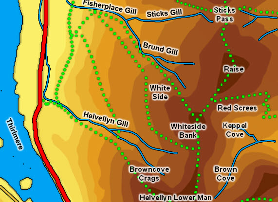
Map
Routes of Ascent
![]() Two paths lead to White Side from the Thirlmere side. Both start on Fisherplace Gill. One then follows Brund Gill and reaches the summit directly. The other cuts across past Brown Crag and below the rocks that give the fell its name. This path comes up to the col between Lower Man and White Side, where we turn left to reach the summit.
Two paths lead to White Side from the Thirlmere side. Both start on Fisherplace Gill. One then follows Brund Gill and reaches the summit directly. The other cuts across past Brown Crag and below the rocks that give the fell its name. This path comes up to the col between Lower Man and White Side, where we turn left to reach the summit.
If coming from Helvellyn head north-west to Lower Man then north along the easy ridge that heads to White Side.
From the east follow the main path up Glenridding, on the north side of the beck. Look out for the major path that branches off to the right, zigzagging up towards Raise. At the top of the main climb this path turns left and heads up towards the summit, on its way to Helvellyn.
Walks
Our ascent of Helvellyn visits Whiteside Bank on the way back down to Glenridding.
The Summit
The summit is a fairly flat area, with a sizable summit cairn. It is mainly grass covered, although with a scattering of stones (the upper end of the white stones), and with a well worn path cutting across it.
Streams and Tarns
 The south-western boundary of the fell is formed by Helvellyn Gill, which rises between Low Man and White Side and runs west towards Thirlmere. Just before reaching the lake the gill is pushed north by the lower reaches of Helvellyn's north-western ridge, and runs in a parallel valley past Thirlspot. This runs into How Beck, and then into St John's Beck north of Thirlmere. White Side thus has no foot on the lake.
The north-western boundary is formed by Brund Gill, which runs north-west to join Fisherplace Gill. This then runs into Helvellyn Gill.
To the south-east and north-east the boundary is formed by the upper reaches of Glenridding Beck, with one stream rising in Brown Cove to the south-east and another above Keppel Cove, to the east of the summit.
White Side has no tarns, but there is the remnant of a small reservoir in Brown Cove.
Other Features
-