
Introduction
![]() Eskdale Harter Fell is one of my favourite fells, a splendid pyramid of a mountain with an interesting summit, in a beautiful location and with spectacular views in every direction.
Eskdale Harter Fell is one of my favourite fells, a splendid pyramid of a mountain with an interesting summit, in a beautiful location and with spectacular views in every direction.
![]() Harter Fell stands slightly apart from the nearby high ground. To the north and east its slopes drop directly down into Eskdale and the Duddon Valley. To the south-west there is a steep drop of around 1,000ft. Even the less steep north-eastern ridge, which runs up to Hardknott Pass, drops 700ft in half a mile before leveling out below Demming Crag. As a result Harter Fell stands out when seen from every direction, and there is no nearby high ground to block the views.
Harter Fell stands slightly apart from the nearby high ground. To the north and east its slopes drop directly down into Eskdale and the Duddon Valley. To the south-west there is a steep drop of around 1,000ft. Even the less steep north-eastern ridge, which runs up to Hardknott Pass, drops 700ft in half a mile before leveling out below Demming Crag. As a result Harter Fell stands out when seen from every direction, and there is no nearby high ground to block the views.
![]() The nearest higher ground is Grey Friar, 2.5 miles to the east, Little Stand on the Crinkle Crags ridge 3 miles to the north-east or Slight Side on the southern side of Scafell, 3.3 miles to the north. From the south around to the west there is no higher ground between Harter Fell and the sea, so this entire area is in view.
The nearest higher ground is Grey Friar, 2.5 miles to the east, Little Stand on the Crinkle Crags ridge 3 miles to the north-east or Slight Side on the southern side of Scafell, 3.3 miles to the north. From the south around to the west there is no higher ground between Harter Fell and the sea, so this entire area is in view.
There are two Harter Fells in the Lake District - the second is part of the Kentmere horseshoe, and overlooks Kentmere, Mardale and Longsleddale in the eastern part of the district.
Statistics
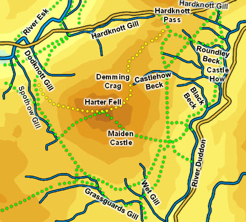
Grid Reference of Summit: SD 218 997
Height: 653m/ 2,140ft
Map
Routes of Ascent
Three paths reach the top of Harter Fell. Of these I've used the western path from Eskdale and the north-eastern path from Hardknott Pass.
The western path is best reached along the path that starts at Jubilee Bridge and climbs up across the north-western slopes of the fell. This path then turns south to head across the pass between Harter Fell and Green Crag, but quickly splits - the left hand branch runs south-east then east to reach the summit. This is my favourite route to the top.
The Hardknott Pass path is clear above Demming Crag and less so below it, but is easy to follow when descending. This ridge can be rather wet, but it does make for a nice circuit when starting from Eskdale.
The Duddon path starts at Birks, in the Dunnerdale Forest, and heads past the crags of Maiden Castle, reaching the summit from the south.
Walks
We have an ascent of Harter Fell from Eskdale returning via Hardknott Pass
The Summit
![]() The summit of Harter Fell is topped by three rocky tors, with a lower one to the south and two higher ones to the north. The north-eastern tor is the highest of the three, although the trig point is on the north-western. The highest point can be reached fairly easily as long as the rocks aren't wet and slippy.
The summit of Harter Fell is topped by three rocky tors, with a lower one to the south and two higher ones to the north. The north-eastern tor is the highest of the three, although the trig point is on the north-western. The highest point can be reached fairly easily as long as the rocks aren't wet and slippy.
Streams and Tarns
The northern boundary of the fell is formed by Hardknott Gill as it flows west from Hardknott Pass into Eskdale. The north-western boundary is formed by the River Esk and the western boundary by Spothow Gill, which flows north into the Esk.
On the Duddon side Grassguards Gill forms the southern boundary and the River Duddon the south-eastern and eastern boundaries. The north-eastern boundary is less clear cut - the divide between Harter Fell and Hard Knott isn't clear on this flank, but one of the nameless tributaries of Castlehow Beck is the main candidate.
Harter Fell can claim quite a few becks that are entirely its own, rising on the fell and flowing into the boundary streams. Most of these are nameless, but DodKnott Gill, flowing north-west into the Esk and Wet Gill, Black Beck and Castlehow Beck, all flowing into the Duddon, have gained names.
Harter Fell has no tarns.
Other Features
Harter Fell overlooks Hardknott Roman Fort, which can be found just to the north of the road over Hardknott Gill, in an impressive location overlooking Eskdale.