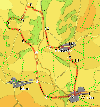
 This walk takes us into the hills north of Winster, in the south east Peak District, close to Matlock. It visits the rocky crags of Hermit's Cave and Robin Hood's Stride, gives us views over Youlgreve and then returns through the village of Birchover.
Ascent: 1,100 feet/ 340 m
Length: 6.8 miles/ 11 km
Map: OS Explorer Map 24 White Peak
Last Walked: 29 May 2007
1: SK 245 606
We start at the car park at the eastern edge of the village. Head west along the main road into the centre of the village of Winster.
2: SK 240 605
We pass through the centre of Winster along the main road. As we reach the western end of the village the main road passes to the right of the church, while a side road leaves the main road and passes to the left of the church. Our path leaves this side road and runs past the churchyard, climbing up through a wooded park before reaching open fields. Just after reaching the fields the path crosses over another minor road and continues across the hillside.
3: SK 231 605
Our path now reaches a junction between farm tracks. We turn slightly to the left and follow the track that leads to the north. Robin Hood's Stride and the crags around the Hermit's Cave should be visible ahead of us.
4: SK 229 610
The farm track now joins a minor road. Cross the road and follow the lane as it continues on to the north, heading downhill.
5: SK 228 618
At the bottom of the hill the lane joins another minor road from the left. Our route now leaves the lane and follows a clearly visible path initially leads directly towards the crag of Hermit's Cave. As we climb the path begins to swing to the left, heading for the gap between Hermit's Cave and Robin Hood's Stride.
6: SK 225 623
Continue up this path as it passes through a band of trees. Once we are past the trees, a path to the left leads onto the crags above the Hermit's Cave. This is a worthwhile deviation from the path, and leads to a superb viewpoint. Once you have enjoyed the view return back along the same path, returning to this point.
Once back at your starting point, cross over the style that leads into the field containing Robin Hood's Stride, and then turn right, crossing another style and cross diagonally across the next two fields. In the field to your right note a small stone circle.
7: SK 223 626
The path now reaches another minor road. Our route follows the farm track on the opposite side of the road and circles around the castle ring at Harthill Moor. If you need to shorten the walk, turn right along the road instead, rejoining our route at point nine.
Our preferred route heads towards Harthill Moor Farm. Follow the path as it passes to the left of the farm (turning left just before the farm and then sharply right). The path then curved gently around the side of the hill, descending rapidly in the direction of Youlgreave.
8: SK 218 629
At the base of the hill, turn right, staying within the same field. The path soon enters a wood, where it continues to turn gently to the right. At the edge of the woods we reach a minor road.
9: SK 223 629
Turn left onto a footpath that runs parallel to the road, before rejoining it after cutting off a corner. Continue north down the country lane.
10: SK 225 634
After the lane straightens out follow it north for about one fifth of a mile. Here a footpath crosses the road. Turn right and follow that path as it heads east across the field. At the edge of this field, the path heads diagonally down the side of bank into the valley of Ivy Bar Brook.
11: SK 230 632
At the bottom of the hill, turn right onto the road. This is a slightly busier road that the others we have seen on this walk, so take care.
12: SK 231 627
After about a third of a mile a minor roads branches off to the left, signposted for Birchover. Take this lane and follow it for a short distance until you find a footpath that leaves to the right. Follow this path as it climbs up a small bank back into open fields.
We are now at the base of a ridge that climbs up towards a small area of woodland. Head up the ridge towards the woods. About half way up we reach a wall heading in our direct. Make sure you are on the right hand side of the wall, as the footpath, and therefore the open gate is on that side.
13: SK 232 621
When you reach the edge of the woods, pass through a gate and turn left onto a track that runs east towards Birchover. In Birchover the Red Lion pub is walker-friendly, with a walkers bar.
14: SK 239 621
Continue through the village until you reach a side road to the right. Turn right and follow this road as it dips down out of the village and then climbs back up to Upper Town.
15: SK 239
At Upper Town the lane narrows. At this point turn left onto a farm track and follow it as it twists right and then left.
16: SK 241 616
Just before the next farm turn right onto a footpath that heads directly towards Winster, now visible across the next valley. Look out for the exotic livestock in the field to the left of the path..
Our path now descents rapidly down the side of the valley. At the base of the valley the path crosses a damp area on a line of stones, still heading directly south towards Winster. Follow the path as it climbs up towards the village. Close to the outskirts of the village our path joins a lane that runs back into the village. Once back on the main street turn left to return to the car park.
