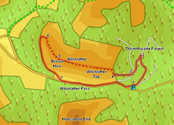
 This shorter walk takes us onto the top of Whinlatter, one of the two fells that overlook Whinlatter Pass. It can be done as a shorter there-and-back walk, or as a longer circular walk that returns along the pass.
Ascent: 1,000ft
Length: 4.5 miles
Map: The English Lakes - North Western Area (OS Explorer Map Active)
Last Walked:
We start from the car park at the Whinlatter Forest visitor centre.
1: NY 208 244
We start by heading east (turn right if facing the visitor centre) along the forest track that runs across the top of the car park, at the bottom of a steep slope that runs up to the visitor centre. This track passes by a cycle hire centre and then splits in two. Take the left hand branch, which runs past a cycle washing station and then gently climbs up through the trees.
2: NY 209 252
We follow this path until it reaches a T-junction with another track. Turn sharply to the left and follow this new track as it runs south-west around the hillside.
3: NY 208 248
This track soon brings us to a crossroads. Head straight across this crossroads, and continue along our track as it heads west, climbing very gently.
4: NY 203 247
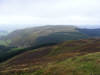
This track brings us to the edge of the forest. From a distance this looks like a dead end, but fortunately a stile crosses the forest fence and takes us onto the open fellside. Turn right and follow a footpath that climbs steeply up the side of the fell, following the edge of the forest. Near the top of the climb a second path branches off to the right - follow this onto the summit ridge, and then follow the clear path that heads west onto Whinlatter Top (the higher of the two summits of Whinlatter), and then on to Brown How (the lower summit).
5: NY 191 251
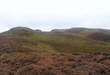
A clear path heads onward from Brown How, but sadly this is rather misleading. Here we will a describe a route that continues on along this path, but be aware that this route does involve some cross-country walking and an few awkward moments. For our walk continue along this path, which drops now the north-western end of the fell.
6: NY 189 256
Eventually this path simply disappears into the heather. At this point a different plantation should be visible just below our current position. Head down the fellside to the edge of this forest, then turn left
and follow the edge of the forest. At first it is possible to walk along the fellside just above the trees, but from time to time the slope becomes too steep for this. At this point it is necessary to use the flat area that runs alongside the fence - this provides the first awkward moment, as the lower branches of the tree are too close to the ground. Things get easier once we reach a cleared area of the forest.
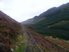
7: NY 192 245
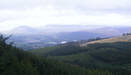
By following the fence we eventually come down to the road that runs through Whinlatter Pass. Another potentially awkward moment comes when we try to cross the roadside fence (just because the fellside is access land doesn't mean that there are easy ways to actually access it!). Once on the road follow it east, as it climbs gently up to the top and then back to the Visitor Centre.
