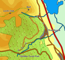
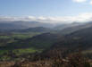
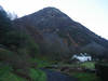
 This walk takes us through Thornthwaite Forest, using the forestry tracks that cut their way across the slopes of Seat How and Ullister Fell. This may not seem a promising route, but at least at the moment forestry clearances mean that we get a series of very impressive views across Bassenthwaite Lake, Derwent Water, Keswick and Skiddaw. This route also takes us to the visitor's centre and restaurant in the Whinlatter Forest Park
Ascent: 1,500ft
Length: 3.1 miles
Map: Explorer 004 English Lakes North West
Last Walked: 17 February 2007
We start this walk from the small car park just north of the old Swan Hotel on the road north from Thornthwaite.
1: NY 220 265
From the car park head back to the road. Cross the road and take the small side road just to the left, opposite the old Swan Hotel. Follow this lane as it curves around to the right.
2: NY 219 263

Just before the lane turns sharply to the left cross over a stile to the right and follow a path that climbs up through some scrubby woodland. The Bishop and the Clerk, two well known stones, are visible to the right.
3: NY 216 263
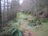
After a short time the route on the right side of Beckstones Gill becomes steeper and rockier. At this point look out of a path that crosses over to the other side of the stream. On the far side of the stream cross a stile that leads into the conifer plantation. Just inside the forest we join a bigger path that climbs straight up the valley. Turn right and follow this path up through the trees.
4: NY 214 264
 We follow this path for about a fifth of a mile as it climbs through the trees. Eventually a path leaves to the left, marked by a post. Turn onto this path, which runs level across the side of the hill. After a very short distance it leads to the end of a forestry track, which we will follow all the way to the Whinlatter
 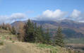 Forest Visitor's Centre.
Although a large number of forest tracks are shown on the map, this part of the walk is actually quite simple to navigate. We need the path that stays closest to level, following the contour line around the hillside. At each junction look for the path that keeps heading clockwise around the hillside without gaining or loosing any altitude.
5: NY 212 247
After curving fairly consistently to the right for most of our route, our track swings sharply to the left after crossing over Comb Gill. It then heads almost due south while slowly loosing altitude. Finally, it meets another track that is climbing up from the left. Remember this track, for we will be using it later on. For the moment turn right and head to the Whinlatter Forest Visitor's Centre.
6: NY 208 244
After stopping at the visitor's centre, we turn round and retrace our steps back to the last junction.
7: NY 212 247
This time take the forest track that runs downhill, ignoring our original path.
8: NY 213 249
After a short distance this track meets another one at a t-junction. Turn left onto this new track, but only for a short distance. Soon a path leaves to the right, heading alongside a small stream. Follow this path downhill. We stay with this path all the way into Thornthwaite. After about a quarter of a mile we reach a forest track, which we cross over and follow the path as it continues down the side of the Comb Beck
9: NY 221 251
Once in Thornthwaite follow the road through the village always keeping to the left, until we reach the road that leads back to our car park.
10: NY 222 258
This is a fairly busy road, so we will take the first chance to get off it. After just over 500 feet, a small road leads off to the left. Take this road, which eventually leads back to the Swan Hotel and the car park.
