
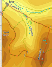
 Whernside is the tallest mountain in Yorkshire, and one of the Three Peaks. As such it is normally climbed from the east, often after a long slog from Pen-y-Ghent. We are going to avoid that busy path, and instead climb Whernside from the delightful valley of Dentdale. This route has a number of advantages over the eastern route. Most obvious is that it is much quieter, something that becomes very clear when we join the main paths near the summit. It visits the Whernside Tarns, a series of dramatic and unexpected lakes perched on the side of the fell. Finally, as we climb we are given a series of spectacular views west towards the Howgill Fells, with the Lake District fells visible further west.
Ascent: 2,450ft/ 750m
Length: 12 miles/ 19 km
Map: Explorer 02 Yorkshire Dales West and South
Last Walked: 29 April 2006
There is a large car park just to the west of the centre of the village of Dent, on the road that runs towards Sedburgh.
![]() We start from the car park on the western edge of the village of Dent. From the entrance of the car park, turn left and head into the middle of the village. The road splits in two around the George and Dragon Hotel in the centre of Dent - take the right hand branch (main street) and follow this road out of the village.
We start from the car park on the western edge of the village of Dent. From the entrance of the car park, turn left and head into the middle of the village. The road splits in two around the George and Dragon Hotel in the centre of Dent - take the right hand branch (main street) and follow this road out of the village.
This road climbs gently up as it runs along the side of Dentdale. Ignore the first right turn, heading to Slack and over the hills to Ingleton and stay on the valley road as it drops back down to cross Deepdale Back. Just after crossing over the beck, turn right onto a road marked as a dead end.
Soon after turning onto the road, turn left onto a farm lane, and then almost immediately right onto a rough track that climbs straight up the north ![]() western slopes of Whernside. We stay on this track for the next mile and a half, gaining 1,000 feet of altitude in that time. As we climb, the views to our west begin to open out, with the Cumbrian fells coming into sight beyond the western end of Dentdale.
western slopes of Whernside. We stay on this track for the next mile and a half, gaining 1,000 feet of altitude in that time. As we climb, the views to our west begin to open out, with the Cumbrian fells coming into sight beyond the western end of Dentdale.
![]() This track falls into four sections. For the first quarter of a mile it runs straight, between stone walls. It then emerges from between the walls, and curves across an open field for another quarter mile. For the next half a mile the track is bounded by a wall to the left. Finally, for the last half mile, as the track begins to level out, it once again runs between two stone walls.
This track falls into four sections. For the first quarter of a mile it runs straight, between stone walls. It then emerges from between the walls, and curves across an open field for another quarter mile. For the next half a mile the track is bounded by a wall to the left. Finally, for the last half mile, as the track begins to level out, it once again runs between two stone walls.
We leave this track where it levels out and emerges from the stone walls and onto the open hillside. Turn right, following the stone wall as it climbs directly up the side of the hill. When the wall ends, keep on going in the same direction, straight up the side of the hill following the clear ![]() footpath.
footpath.
Our path now brings us to the Whernside Tarns, a number of surprisingly large bodies of water that seem to sit precariously on the edge of the hill. Take time out to investigate these fascinating pools, before continuing along the same path as it climbs gently along the long ridge that makes up the summit of Whernside (now clearly visible beyond the tarns). On this part of the walk the views east begin to open up as Ingleborough begins to come into view.
![]() The summit of Whernside is split in two by a stone wall that runs from north to south along the highest point of the fell. After enjoying the views from the eastern side of the fell, use the stile to cross over onto the very different western side of the summit.
The summit of Whernside is split in two by a stone wall that runs from north to south along the highest point of the fell. After enjoying the views from the eastern side of the fell, use the stile to cross over onto the very different western side of the summit. ![]() Here a wide grassy plateau gently slopes down to the west. Take the path that heads due west across this plateau.
Here a wide grassy plateau gently slopes down to the west. Take the path that heads due west across this plateau.
After just under half a mile we reach the edge of the summit plateau. Here the path jinks to the right before continues to head west, this time running alongside a stone wall.
![]() There are two routes on from here. If you are running short of time (or energy!) then continue along this road as it drops down into Deepdale. Eventually it reaches the road we used earlier to leave Dent - turn left and head back into the village.
There are two routes on from here. If you are running short of time (or energy!) then continue along this road as it drops down into Deepdale. Eventually it reaches the road we used earlier to leave Dent - turn left and head back into the village.
The more interesting route follows Green Lane and runs around the slopes of Great Coum. This route gives great views down into Dentdale, but can be a little muddy, at least to start with. After about a third of a mile on the road, turn left on Green Lane. This track begins with a sharp curve to the left, running to the south of High Pike. It then cuts across Foul Moss to reach the slopes of Great Coum.
Between the time we turn onto Green Lane and the time we leave it, there is only one junction in the path. Just under three miles after we left the road, the track splits. One branch runs north east, and heads down hill into Deepdale, while the other branch turns left and continues to run around the side of the hill - take the left hand track.
We follow this part of the track for just over a mile. It then turns sharply to the left and curves around the valley of Flinter Gill. Just after crossing the gill, turn left onto a track that heads straight down the hillside towards Dent. This path follows the side of Flinter Gill all the way down into the village, finally reaching the main road just opposite the car park.