
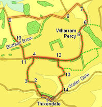
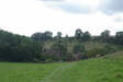
 This rather unusual figure of eight walk starts from the pretty Wolds village of Thixendale, nestled in the bottom of one of the steep sided dry valleys, or wolds, that give the area much of its character. From there it climbs up onto the top of the hills, and heads for Wharram Percy, one of the most studied abandoned medieval villages in the country. This stage of the walk also offers us some very impressive views north towards the Yorkshire Moors.
The second half of the walk almost takes us out of the Wolds and into the Vale of Pickering, dropping down towards Birdsall, before climbing up Birdsall Brow to another superb viewpoint. Finally we return across the top of the Wolds, repeating our steps for short period, before returning to Thixendale from the east.
Ascent: 1,300ft/ 400m
Length: 11 miles/ 18km
Map: Explorer 300 Howardian Hills and Malton
Last Walked: 29 March 2007
 We start on the main street in Thixendale. Head west through the village (with the pub behind us at the eastern end of the village and the church to our left). At the western end of the village turn right, onto a track that climbs up the side of the valley (just past the last buildings to the right, and opposite a farm to the left). Follow this track as it
 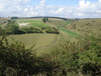 climbs up the hillside, curving around to the right. At the top of the climb the track turns more sharply to the right, heading towards some farm buildings. At this point leave the track and follow a signposted footpath that continues on to the north west, rejoining the track on the far side of the farm buildings. Continue along this track.
 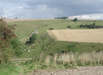 We follow this track until we reach a footpath that leaves to the right. Turn onto this footpath and follow it as it runs north along the edge of the next field, running to the right of the field wall. This path leads to the southern edge of another steep sided valley, at the point where three dales meet - Vessey Pasture Dale to the left, Back Dale to the right and a short un-named dale to the north. Our path drops down into this valley, and then climbs back out along the un-named dale. At the top of the climb out of this dale our path continues to the north, along the right hand side of the next field.
 At the far end of this field we reach a small clump of trees. We pass through these trees, and then reach a T-junction in the path. Here the Centenary Way goes left and the Wolds Way goes right. For the moment we are following the Wolds Way, so turn right, and follow this path east across the top of the hills, with the open field to our left, and either a hedgerow or one of a series of small plantations to our right.
When we join this path, the fields to our left slope are fairly level, with no more than a slight dip in the middle, but as we head further along the path that dip rapidly turns into Deep Dale, a typical steep sided Wolds valley. We stay on this path for the next two miles as it runs along the bank above Deep Dale, with the valley to our left.
 We leave the top of this bank just before the abandoned village at Wharram Percy. The point where the path drops down into the valley is fairly obvious - start looking for it at the point where another dale (Drue Dale) joins the far side of Deep Dale.
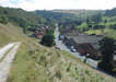
 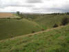 Follow the path down the hillside, and into the churchyard at Wharram Percy. It is well worth spending some time exploring the abandoned village - although very little is now visible above ground, the site is well signposted. When you have finished here, continue on to the north, following the path that passes to the left of the old farm house just beyond the church. Follow this path as it runs back down into the valley bottom.
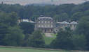
 About a third of a mile after the start of this climb we reach a potentially confusing road junction. First we reach a T-junction, where a side road leaves to the right. Ignore this side road. The OS map now shows our road continuing on in a straight line for some distance before the next turn, but only a few feet after the T-junction we are faced with what appears to be a split in the road. In fact the left hand branch is a private farm road, but one of very high quality, so take the right hand branch, heading to the right of a narrow band of trees visible on the skyline.
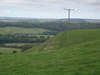
We now follow this road for the next two miles. At the narrow band of trees it turns sharply to the right, and runs across the top of the hill for a short distance, before reaching the top of Birdsall Brow. For the next mile the road winds its way down the side of the brow, passing Picksharp House, and only straightening out when it reaches more level ground. For the final half a mile of this section, the road runs almost due west, with Birdsall Brow dominating the view to the left.
 At the end of that field, the track reaches the base of Birdsall Brow, and begins to climb up the brow. After a short distance the main track swings away to the right, but a smaller track, signposted as a footpath, continues to climb straight on up the bank. Take this signposted footpath and follow it all the way to the top of the brow, past Toisland Farm, and on across the hilltop beyond.
 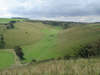 We follow this path as it heads south across a large open field, then stay with it as it turns left, and then right. At this right turn ignore the footpath that heads away to the left. About 900ft after this right turn, the track kinks a little to the left. At this point the Centenary Way leaves to the right. Turn right and follow this footpath as it leads to the edge of Court Dale.
Here the path turns left, and runs along the top of the eastern slopes of the dale, heading towards Water Dale.
 At the southern end of Court Dale, the path drops down the hillside into Water Dale. Turn right and follow the path through the next two fields to a side road at the edge of the village of Thixendale. Follow this road past the pub and back onto the main road, and our starting point.