 This is a lovely short walk that takes us from Ulpha up to the minature summit of Stickle Pike, a super viewpoint with contrasting views of the high fells to the north and the more gentle fells towards Cumbria's coast to the south.
Ascent: 1,050ft
Length: 2.9 miles
Map:  Lakes South West
Last Walked: July 2013
We start from the small area of road side parking on the southern side of the bridge over the River Duddon at Ulpha.
1: SD 196 930
Head south down the road for a short distance (away from the bridge), then turn left onto the drive that leads up to Birks (signposted as a right of way).
2: SD 200 929
This drive brings us up to the house at Birks. Here the path splits, with the left-hand branch heading into some trees while the stony right-hand branch climbs up the right-hand side of the trees. Take this right-hand branch. This path is fairly clear, apart from one section where it crosses a wet area. Ignore any side branches until you reach the valley of Hollow Moss Beck.
3: SD 206 931
Here the path splits - the main path continues straight ahead, dropping down to cross the beck and then climbing up the opposite side. Ignore this path and instead take the right-hand branch which runs alongside the side of the valley. This brings us to a circular sheep fold and an easy crossing of the stream.
4: SD 207 931
This brings us to the one awkward junction on the route. After we pass the circular sheep fold and cross the stream the clear path curves back to the left. The OS map shows a clear path junction, with the right of way forming the right-hand branch, but the junction isn't at all clear on the ground. Look for a rectangular area of clear ground surrounded on three sides by bracken, roughly level with the sheep fold. Our path emerges from the far-left corner of this rectangular area and climbs up between rocky outcroppings heading up towards the northern ridge of Stickle Pike.
5: SD 212 932
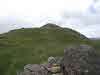
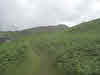
We follow this path as it climbs up towards the top of the ridge that runs north from Stickle Pike. At the top of the climb a series of small paths branch off to the right, but they all quickly merge into a single simple path that heads south along the ridge (tending to follow the right-hand side), eventually reaching the lovely summit of Stickle Pike, which sticks up just above the main ridge.
6: SD 211 927
7: SD 213 926
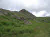
Just as the path reaches the southern end of the crags of Stickle Pike a minor path branches off to the right. Turn right onto this path and follow it as it curves around the southen end of the Pike. This brings us to the top of the valley of Hollow Moss Beck. Follow the path north down the valley.
8: SD 208 926
Eventually the path disappears at the edge of some wetter ground. Continue to head north down the valley, heading towards the same circular sheepfold. Eventually we reach the original path - turn left onto the path and follow it back to Ulpha.
