
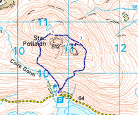
 Stac Pollaidh is perfect proof that a great mountain doesn't need great height. At 612m/ 2,008ft Stac Pollaidh is an absolute minnow, but its isolated position, dramatic shape and spectacular views lift it into the top division of mountains. The mountain has a steep grassy base, rising to dramatic sandstone crags. The views in every direction are spectacular, from the Atlantic coast to the west, the watery wilderness of Inverpolly Forest to the north to the surrounding mountains (Suilven to the north, Cul Mor and Cul Beag to the east, Ben Mor Coigach to the south). We start close to Loch Lurgainn, and just to complete the mountain's charms there is an easy walkers route up to the shoulder between the two rocky summits.
Ascent: 1,500ft
Length: 2.5 miles
Last Walked: Autumn 2011
We start from a small car park on the road between the shore of Loch Lurgainn and the lower slopes of Stac Pollaidh.
Eventually the path splits in two. The lower branch continues on around the mountain, but our path heads off to the left and climbs up to the shoulder between the two rocky summits.
![]()
![]()
![]()
![]()