
 This short walk takes us to Small Water, one of the most dramatically placed of the Lake District's tarns, nestling at the base of a circle of crags. This is also one of the more isolated parts of the Lakes, with the only road access being along the side of Haweswater.
Ascent: 725ft/ 220m
Length: 2.2 miles/ 3.5km
Map: Explorer 05 English Lakes North East
Last Walked: 29 August 2006
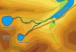
We start this short walk from the car park at the far end of Haweswater. Be aware that this is quite a small car park, and there is no alternative parking, so try to arrive early on busy days.
Take the only path that leaves the car park, heading south west, running alongside a wall. At the end of that wall the path splits into three. We want the middle path, running diagonally across the middle of the field (the left branch heads to Gatesgarth Pass and the right branch to the head of the lake).
Follow this path all the way to Small Water, always keeping the line of the beck to the right (Mardale Beck at first and then Small Water Beck for the rest of the walk).
![]()
![]()
![]()
![]()
![]()