
 Shacklesborough is one of the few distinct landmarks on the moors at the head of Baldersdale and Lunedale, and a fantastic viewpoint. It is a flat-topped hill, surrounded by a circle of crags, with views into the heart of the north Pennines, south in the Dales and on a very clear day the Cumbrian mountains are just visible between gaps in the hills. From the car park at the southern end of the Balderhead dam, Shacklesborough is only one and a half miles away, with great views all along the walk.
This is a fine weather walk. The views are distant panoramas, and need good visibility, and the moorland is exposed to the elements. Avoid on foggy wet days.
Ascent: 392 feet/ 120 metres
Length: 3 miles/ 4.8 km
Map: OS Explorer Map 31 North Pennines: Teesdale and Weardale
Last Walked: 18 February 2007
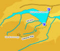
To reach the Balderhead Reservoir follow the B 6277 between Barnard Castle and Middleton in Tees. Take the turn for Hunderthwaite (between the villages of Cotherstone and Romaldkirk). The road passes the northern bank of Hury and Blackton Reservoirs. The turn for Balderhead reservoir comes just after the Pennine Way crosses the road. Turn left through an elaborate gate onto a lane that leads down to the reservoir.
Parking is available at both ends of the dam. This walk starts from the southern end of the dam, but you can park at the northern (near) end and walk across the dam.
There are two ways back to car from here. In anything other than perfect weather turn back and follow the same track back along Galloway Rigg. This route probably has the better views.
On a good clear dry day, it is possible to head north east from the foot of Shacklesborough and use the network of tracks that cross the moor. From the top of Shacklesborough a line of poles is visible to the north. From the base of the hill, head north until you find a track that leads to these poles. Up close they turn out to be a line of grouse butts, built into a stream bed. Keep to the right of this stream (Gill Syke) until it turns sharply to the right, at which point you will need to cross over to the north bank.
Just after crossing this stream you will reach a sheep fold. Turn right hear along the tracks that are now heading directly back towards the Balderhead Dam. This track crosses back across Gill Syke, before reaching a stone wall. This is the wall we left back at the Leeds Grammar School buildings. Ignore the tempting gate in the wall - that route is wet and muddy. Instead follow the path close to the wall back to the outdoors centre, and then return to the car.