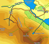
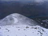
 The most famous route up Red Pike goes up the scree slopes on the north-eastern ridge, but there are several alternatives, including this route, which visits Scale Force - the tallest waterfall in the Lake District, and then heads along the top of Lingcomb Edge, a fine line of approach to the shapely summit.
Ascent: 2,500ft
Length: 7 miles
Map: The English Lakes - North Western Area (OS Explorer Map Active)
Last Walked: January 2010
We start from the National Trust car park above Buttermere Village
1: NY 172 172
Turn right out of the car park and follow the road down into the village
2: NY 175 169
Just past the Bridge Hotel turn right into the village. Head past the left of the Fish Hotel, on the track that leads down to Buttermere lake. Just past the hotel this track turns sharply to the left. After a short straight stretch a second track branches off sharply to the right. Pass through the gate that leads onto this track and follow it as it runs straight across the fields towards Buttermere Dubs.
3: NY 167 165
Just before reaching the river the track turns right, then turns left and crosses Scale Bridge. On the far side of the bridge turn right onto the path that runs towards Crummock Water.
4: NY 163 169
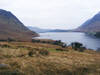
Soon after the path reaches the lake it splits in two - one path heads off diagonally and to the left, heading up the fellside, while the other continues along the lake-shore. Take the left-hand branch. This path curves around to the left, passing below Blea Crag, climbing most of the time. Eventually the path passes through a gate in a stone wall and reaches Scale Beck.
5: NY 151 171
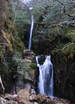 Our route onwards uses the footpath that heads off to the right, climbing up through the trees to the left of the beck, but first take the time to drop down to the beck and visit Scale Force in its dramatic rocky ravine.
After visiting the waterfall return to the path up. The first section zig-zags through the rocks to the left of the stream, It then levels out a little and runs along the steep slope above Scale Beck (this part of the path is a little and in places feels quite precarious).
After this level section the main path turns left and heads up the hillside. Follow this path as it climbs up through the heather.
6: NY 155 163
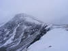
This path brings us up to Lingcomb Edge. Turn right onto the path that runs alongside the edge and follow this path all the way up to the summit of Red Pike. On the way up note a junction were a second footpath joins from the right - we will be using this later.
7: NY 160 154
There are two choices of route back from Red Pike. Our route simply retraces its steps back along Lingcomb Edge and down Scale Beck, but it is also possible to take the rather more dramatic path down the north-eastern front of the fell, towards Dodd and
Bleaberry Tarn. This path is very clear all the way down to the edge of Buttermere. If conditions don't allow or the steep, rather nasty path down Red Pike doesn't appeal then head back down the the western slope of the Pike and along Lingcomb Edge
8: NY 155 161
Turn left at the junction noted earlier. This path gives a different view of the large bowl in the hills formed by the the back of Lingcomb Edge, Little Dodd, Starling Dodd and Gale Fell, before reaching Scale Beck, where it turns right and follows the stream all the way back to Scale Force. After that we retrace our steps back to the start.
