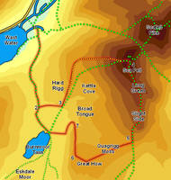
 This ascent of Sca Fell from Wast Water avoids the most popular paths for most of its length, visiting the quiet area above Burnmoor Tarn before climbing up the western slopes of the mountain. On my walk I didn't see another walker between Burnmoor Tarn and the summit!
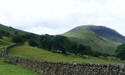
Even the summit of Sca Fell itself can be relatively deserted compared to the nearby Scafell Pike, despite being a much more interesting place.
Be aware that large parts of this walk head away from established footpaths, especially the section on Great How.
Ascent: 3,300ft
Length: 9 miles
Map: The English Lakes - South Western Area (OS Explorer Map Active) (OS Explorer Map Active) Last Walked: June 2009
We start from the National Trust car park at the head of Wast Water.
1: NY 182 074
Turn left onto the track that runs alongside the car park. Follow this track through a gate, and then cross the bridge over Lingmell Beck. On the far side of the bridge turn left and follow the track that runs alongside the beck, until it splits in two. Here take the right-hand track, which heads away from the beck, and follow it as it climbs diagonally up the fell side into the gap between Sca Fell and Illgill Head.
2: NY 184 053
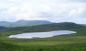
My plan on this walk was to follow this track onto the pass between the two mountains, and then use the footpath marked on the OS map to cut across to Hard Rigg, where a path runs up the southern front of Sca Fell. Unfortunately the connecting path is not visible on the ground, so a short cross-country diversion is required. Follow the track until it begins to drop down towards Burnmoor Tarn. Turn left at the edge of the flat swampy ground that surrounds the tarn, and head east until you reach the start of a clear path heading up the slope to the left.
3: NY 190 052
Turn left onto this path, which climbs up Hard Rigg, with Hardrigg Gill to the right. Follow this path as it climbs up alongside the gill, then swings off to the left to join the footpath that runs up Green How, climbing up the western flank of Sca Fell. Follow this path all the way to the summit ridge.
4: NY 206 065
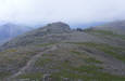
This path reaches the summit ridge in a dip between Symonds Knott and the summit itself. Turn right to reach the summit. From here a path runs south-east along a ridge that runs down from Sca Fell itself, over Long Green and down to the craggy top of Slight Side.
5: NY 207 044
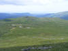
Our route onwards from Slight Side takes us away from existing footpaths, across Quagrigg Moss and on to Great How (the summit of Eskdale Fell). At first we follow the footpath that heads down from Slight Side towards Eskdale, but when the path begins to curve away to the left leave it and head right towards the rocky summit of Great How. Take care crossing the Moss.
6: NY 193 041
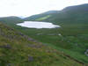
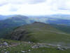
The summit of Great How is an excellent viewpoint for Burnmoor Tarn, seen at the foot of Raven Crag, but we are now faced with the problem of how to get past the crags. Head towards the crag and then turn right and follow the grassy summit as it heads north, and drops down towards Oliver Gill
7: NY 193 048
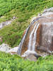 As we approach Oliver Gill the slope ahead looks unpleasantly steep, but as is often the case this is something of an illusion. Look for a waterfall in the gill (pictures right), and head down the grassy slope above the falls. This brings us to a footpath that runs around the base of the crag. Turn left and follow this footpath as it runs south, with the crags to the left and the tarn to the right.
Our problem now is how to cross the swampy area between our current path and the track from the tarn back into Wasdale. The simplest solution is to follow our path south until it joins the footpath coming up from Boot to the tarn. Turn right onto this path, and then follow it as it crosses a bridge over Whillan Beck (Lambford Bridge), then turn right onto the path that heads north, passing to the right of Burnmoor Tarn. We are now the track we used to climb out of Wasdale, so follow it as it runs past the Tarn, climbs up onto into the gap between Sca Fell and Illgill Head and finally down into Wasdale and back to the NT car park.
