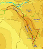
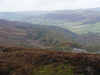
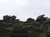
 There are very few places where the junction between lowland and upland England is as visible as on the Roaches. From the summit of this rocky Peak District ridge one can look south towards gentle green fields or north across high moors that extend in an almost unbroken sequence to the Scottish border. The Roaches themselves are a line of impressive cliff faces that are a popular destination for climbers, while the path above the cliffs is a fine ridge walk.
Our walk begins by curving behind the Roaches to visit the chasm of Lud's Church, a rocky cut in the hillside now believed to be central to the story of St. Gawain and the Green Knight.
Ascent: 1,370ft
Length: 8 miles
Map: Explorer 24 White Peak
Last Walked: 15 October 2008
The road along the base of the Roaches is lined with parking spaces. Here we start from one of the first of these spaces, at the foot of Hen Cloud. To reach that road leave the A 53 at Upper Hulme.
1 (SK 006 617)
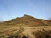 From the car head north towards the Roaches. After a short distance the road turns to the left. Just after this a signposted footpath leaves to the right, passing through a narrow gate in the stone wall. Take this path, and follow it along the right hand side of the first field and half way along the edge of the next field, until it crosses the path that runs from the Roaches onto Hen Cloud.
2 (SK 007 620)
At this point turn left and cross the field, heading towards the craggy southern end of the Roaches. Pass through a gate at the far side of the field, and then turn right onto a good path.
3 (SK 007 620)
We now follow this path for just under a mile, as it runs north-east around the eastern slopes of the Roaches. For the first third of a mile this path climbs up towards what appears to be a gap between the main Roaches ridge and an outlying hill, then it runs fairly level to the road.
4 (SK 012 632)
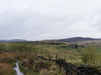
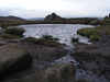
This path brings us out onto a minor road that runs along the eastern side of the Roaches, overlooking the valley of the Black Brook. Turn left onto this road and follow it as it runs north west, slowly climbing as it goes.
5 (SJ 995 644)
Eventually our road crosses the top of the Roaches ridge and runs south-west down the far side. Leave the road at the point where the road turns left to cut across the ridge, and cross over a stile in the wall directly ahead. On the far side of the wall turn right and follow a path that runs north, heading down hill towards the Black Brook.
6 (SJ 995 649)
Follow this path into Forest Wood. Just inside the trees we reach a signpost at a t-junction in the path. Turn left and follow the path signposted for Lud's Church and Swythamley. This path runs level through the trees, heading north-west along the back of the hill.
7 (SJ 990 653)
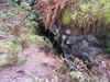
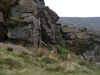
After some distance in the woods, the path splits in two. Take the left hand branch, which is signposted for Lud's Church. After quite a muddy patch in the woods, the path reaches the southern end of Lud's Church, a dramatic chasm.
 After reaching Lud's Church the path runs to the left of the chasm, and then follows a flight of stone steps down to the bottom of the ravine. Follow the path
  as it runs downhill through this very impressive rock feature.
After leaving Lud's Church turn left and follow the path as it continues to run around the back of the ridge. After a short distance the path runs out of the woods, and curves around to the left, eventually reaching the top of the ridge.
8 (SJ 977 653)
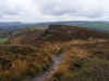
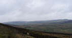
A good footpath runs east along the top of the ridge. Turn left onto this path, and follow it all the way back to the southern tip of the Roaches. After just
under a mile and a half we cross the same road we used earlier, and climb up onto the top of the main Roaches ridge. After a climb up to the trig point the path runs slowly downhill along the top of the crags, passing Doxey Pool on the way.
9 (SK 006 622)
There are several different routes from the top of the Roaches down to the road, any one of which is equally interesting. The first route runs down a ravine that cuts into the cliff face. On this occasion ignore this path and continue along the
main path, which runs between some very popular climbing routes. After around 800 feet another rocky staircase runs down the smaller cliffs to the right - our route uses these steps to reach the trees below the cliffs. From the bottom of the steps follow any of the many paths that run downhill back to the road.
