
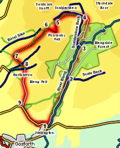
 Ponsonby Fell is not one of the most interesting fells in its own right, but it does sit on the edge of some of the most remote country in the Lake District - the empty quarter south of Ennerdale. This walk starts with a walk through the beautiful Blengdale Forest, before passing the isolated farm at Scalderskew on its way to Ponsonby Fell. After a diversion to the summit of the fell we head into more settled country on the western flanks of the fell.
Ascent: 1,000ft
Length: 6.25 miles
Map:
Last Walked: Autumn 2013
There are two possible starting points for this walk. In both cases head through Gosforth and Wellington until you reach the east end of the village, where the main road turns right to cross a bridge over the River Bleng (on its way to Wasdale). Ignore the turn and head straight ahead onto a side road.
Normally you can use a small Forestry Commission parking area at entrance to Blengdale Forest. Follow this side road until it turns left - again ignore this turn and head straight on along a track (ignore the private road signs - this is a legitimate route to an acknowledged parking area).
At the time of writing (Winter 2013) this car parking area is out of use as it is being used for Forestry operations (connected to the need to remove Larch from the forest). If this is still the case on your visit then park on the side of the minor road before the track - there is plenty of space on the left.
We follow this path until it reaches a new footbridge over the river (older OS maps still show the older footbridge, which was a little further up the river but was damaged by floods). Cross the new bridge. Ignore the right of way marked on the map - what looks to be the start of this path is actually the remains of the path to the old bridge. Instead take the forest road striaght ahead and follow it as it zig-zags up the steep slope between the River Bleng and Scalderskew Beck.
This track eventually levels out and merges with another track that comes in from the right. At this point the edge of the forest can be seen in the distance, so follow the track as it heads north along Bleng Tongue. After it emerges from the forest keep on the track as it curves around to the left, following it until it reaches Scalderskew Beck.
This next bit of the walk is rather wet underfoot. The track runs down to the beck, crosses over it and runs up towards the isolated farm at Scalderskew. Our route is in the open field to the left of this track. Look for a gate in the wall to the left of the track, with a footpath sign. Cross the beck and pass through this gate. At this point the path rather disappears.
Head uphill, keeping parallel to the wall (but not too close as that is the wetter side of the field). At short distance after passing the farm the track marked on the OS map can be found, but it is now more of a muddy ditch than a useful route. Instead follow the faint path that runs just to the left of the old track, heading towards the skyline.
As you get closer to the skyline look for a suitable place to branch off to the left to head towards the summit of Ponsonby Fell. This is a fairly good viewpoint, with some glimpses of distance fells, and a good view out to sea, but the best view is of the wild and empty upper reaches of the Bleng and of Worm Gill, looking at the back of the fells on the southern side of Ennerdale.
![]()
![]()
![]()
At the summit turn right and head west down the side of the fell, heading towards a gate that can just be seen in the wall at the base of the slope.