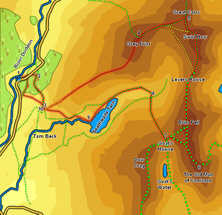
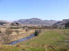
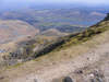
 The Old Man of Coniston is one of the most popular of the Lakeland fells, and the tourist routes up from Coniston some of the busiest paths. This alternative route takes us up onto the Coniston fells from the very quiet Duddon Valley, mixing the quiet (pathless in places) fells on that side with the much busier summits above Little Langdale and Coniston.
Ascent: 3,000ft
Length: 9 miles
Map: The English Lakes - South Western Area (OS Explorer Map Active)
Last Walked:
We start at the Forestry Commission car park at Froth Pot in the Duddon valley.
1: SD 234 995
Follow the grassy path that heads left out of the car park onto the road, then turn left onto the road and follow it up the valley for a short distance. Ignore the first footpath that leaves to the back-right, but instead turn right onto a forestry track that cuts diagonally up across the hillside.
2: SD 238 996
This track runs straight for a short distance, then begins to curve around to the right. Just about at this point turn right onto a footpath that continues to climb up the hillside, but heading in the opposite direction to the track. Follow this track as it climbs up and over Pike How and then drops down into a hidden valley, eventually reaching the edge of the trees at a stone wall. Follow a path that climbs diagonally up the hillside to the left, eventually running parallel to a stone wall. Follow this path until it reaches a gate that passes through the wall.
3: SD 240 988
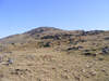
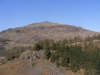
On the far side of the gate the path splits. One branch heads off to the right, while another climbs straight up the hillside. Take this second path, which brings us up onto the western end of the long craggy ridge that leads up to Grey Friar. At the top of the bracken the clear path rather fades away, leaving us to make our own way up the ridge. You can't go far wrong by simply heading for the highest point visible on the skyline at any point. Eventually we reach the end of this craggy ground, and the summit of the fell comes into sight. At this point veer right to reach a footpath and follow it to the summit.
4: NY 260 004
5: NY 270 008

Turn right at the summit of Great Carrs and follow the ridge that runs around to
Swirl How. At Swirl How turn through ninety degrees to the right and follow the
ridge that runs down to Levers Hawse, then across
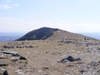
Brim Fell, before finally reaching the Old Man of Coniston. Note the path that comes up to join our route from the right just as we reach the Old Man - this is our route onwards.
6: SD 272 978
From the summit of the Old Man turn back and retrace your steps until the other footpath branches off to the left. Turn onto this path and follow it down to Goat's Hawse.
7: SD 265 982
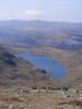
Turn right at Goat's Hawse and follow the faint footpath that runs down the right-hand side of Far Gill into the valley of
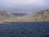
Seathwaite Tarn.
8: SD 263 992

This path eventually brings us down to the swampy area above the tarn. Pick your way across this wet area (after very wet weather it may be worth heading upstream for some way first). Once across the valley floor turn left and follow an increasingly clear path that runs along the right-hand side of Seathwaite Tarn, eventually reaching the dam.
9: SD 250 987
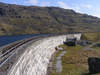
A clear path continues on down the valley from the dam, running to the right of the stream. This path tends to run a little to the right of the path marked on the OS map, and eventually reaches a point where it is signposted as turning sharply left, towards another footpath sign. Ignore this turn and continue on to the west, and you will soon reach the point where the path we used at step three began to fade out. Follow this path back down to the gateway in the wall.
10: SD 240 988
This time we will take a different route around the outcrop of higher ground between us and the car park. A stile is clearly visible crossing the wall on the opposite side of the valley below the stone wall. Head down the slope to reach this stile, which leads to a path that climbs up and over The Hows (passing to the right of the main crags). On the far side of this little ridge our path reaches a right of way - turn right onto this path and cross a stile that brings us into some woodland. Follow this path back to the road, then turn left to return to the car park.
