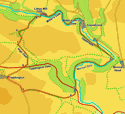
 This walk follows the River Wye as it passes through some of the most dramatic river gorges in England - Miller's Dale, Water-cum-Jolly Dale and Monsal Dale - where the Wye runs between tall cliffs or steep hills.
We also pass through some typical White Peak scenary in the middle stage of this walk, when we leave the Wye to climb up onto the hills above the village of Taddington.
Ascent: 1,460ft/ 450m
Length: 7.8 miles/ 12.6km
Map: Explorer 024 White Peak
Last Walked: 7 June 2008
We start from the small car park in Upperdale, easily accessible from Monsal Head - take the side road that runs between the main and overflow car parks, heading steeply down into the Wye valley. This is quite a small car park (I was able to find a space on a Saturday in early June, but may well be full in the holiday season), so if it is full start from the car park at point 3, on the A 6 just to the west of Ashford in the Water.
1: SK 176 721
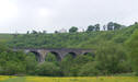
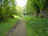
Starting at the car park turn right, towards the small cluster of buildings in Upperdale. Just past the first of these buildings turn right onto a minor lane that crosses the River Wye, and then turns to the left and climbs up the side of the valley. After a short distance this track passes under a railway bridge. On the far side of a bridge turn left and follow a path that brings us onto the old railway that now forms the route of the Monsal Trail. From the path turn right onto this railway, heading away from the bridge we have just passed under, and follow the railway down the valley.
2: SK 181 716
We follow the railway for about a third of mile, until we reach a point where the River Wye swings dramatically around to the right. While the railway crosses the
river and then enters a tunnel, our path leaves the railway just before the river bridge. Just as the river bridge comes into view, turn right through a gate that leads to a path that drops steeply down onto the valley bottom. Turn right and follow this path as it runs alongside the River Rye.
3: SK 170 706
Eventually this path brings us to the A 6. Carefully cross this often busy road and enter the car park on the far side of the road. Turn left and walk a few feet down the car park, then turn right onto a footpath that climbs up a grassy slope. This path curves gently up to the right, and gives us a nice view down the Wye Valley.
4: SK 169 705
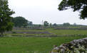
After a short distance turn right onto a footpath signposted for Taddington. The first part of this path is a little indistinct as it passes over a minor limestone pavement, but it soon brings us into a small side valley where the path is more obvious. This path brings us to Taddington Field farm, where we join a minor lane, which we follow for just under half a mile.
5: SK 153 705
This lane eventually joins a slightly busier lane at a T-Junction. Turn right onto this lane and follow it to the edge of the village of Taddington. Turn right onto the short road at the eastern edge of the village, and then right again onto a lane that runs downhill back to the A 6.
6: SK 153 713
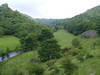
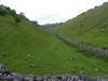
Once again cross the A 6 carefully - at this point the road is partly a dual carriageway, with a grassy barrier in the middle which makes it much easier to cross. On the far side of the road a minor lane climbs up the opposite side of the valley, contining on in the same diraction as the lane from Taddington. After just under 500 feet this track reaches the edge of a large field. Turn left and follow the edge of this field. At the far side of this field we drop down into High Dale, a steep sided dry valley, more typical of areas like the Yorkshire Wolds. Turn left and follow the path that runs along the bottom of this valley.
7: SK 151 719
After about a third of a mile, at the end of a stone wall which runs along the valley bottom, a side valley leaves to the right. Turn right and follow the path that runs up this side valley. This path passes through three fields before reaching a minor lane - note that in the second field the path curves a little to the left, and passes through a narrow gap in the field wall, ignoring the more obvious track to the right. Turn left onto this lane.
8: SK 151 724
Ignore the footpath that leaves to the right almost immediarly after we join this lane, and continue along this lane until it turns sharply to the left. At this point turn right and follow a footpath that runs though a small nature reserve.
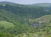
This path brings us to a spectacular viewpoint overlooking the River Wye as it runs through its ravine - here we are looking at Miller's Dale and the side valley of Tideswell Dale. The best viewpoint into Miller's Dale lies just a little to the right of path, on some grass covered industrial remains.
9: SK 158 729
After passing this viewpoint the path drops down into Miller's Dale, bringing us back to the old railway that is now the Monsal Trail. Our path brings us to a bridge across the
railway. Don't cross this bridge - instead turn right and follow the path as it drops down onto the railway. Just to the right of the bridge a footpath leaves the railway and drops down through the trees to Litton Mill -take this footpath down to the valley bottom, then across a footbridge over the river and into the buildings.
10: SK 158 730


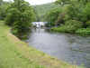
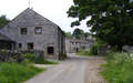
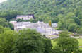
This path brings us out onto a pretty village street. Turn right and follow this path towards the mill itself. Pass through the mill gates then follow the path through the middle of the mill. At the far end of the buildings the path swings right then left, and then follows the Wye as it runs through one of the most impressive river gorges in England.
11: SK 172 728
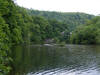
This concessionary path eventually brings us to Water-cum-Jolly Dale and Cressbrook. Here the path follows the base of the cliffs as it runs around the edge of the mill pond for Cressbrook Mill. Our path then

crosses the Wye on a footbridge just below the weir for this mill pond. On the first side of the bridge our path climbs up a short flight of steps to the right, then swings left and continues to follow the Rye valley. Eventually this path rejoins the Monsal Trail. To our left we can see the blocked tunnel that has
forced the trail to use this beautiful diversion. Our route follows the trail back to the point we first joined it back at step one. From our bridge we retrace our route back to Upperdale and the car park, leaving the railway to the right, then turn right onto the old station road and follow it back down to the river.
