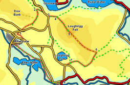
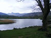
 This walk takes us between two of the major valleys of the central lakes, starting close to the Brathay, the river of Little Langdale, then crosses over to Grasmere and Rydal Water, on the Rothay, before returning across Loughrigg Fell, a much better viewpoint than its height would suggest.
At the right time of year (early May in our case) the final part of the walk takes us through a series of bluebell woods on the banks of the Brathay.
Ascent: 1,400ft
Length: 5.5 miles
Map: Map: The English Lakes - South Eastern Area (OS Explorer Map Active) 
Last Walked:
We start at the small NT car park just to the north of Elterwater village, on the opposite side of the road into Great Langdale.
1: NY 329 050
Turn right onto the minor road that runs past the car park, and follow it as it curves around to the right and heads east across the hillside. Where the road turns sharply left leave it and follow the footpath that continues in the same direction. This very quickly brings us to another minor road. Turn left onto this route and then almost immediately right onto the best of a number of alternative footpaths that continue on to the north-east, running underneath Huntingstile Crag. Follow this path to a small stone building at the foot of a steeper section. Here there is a choice of two routes - the most obvious path runs directly up the slope, but a better route (if the bracken allows), zig-zagged right and then left to reach the same point. Continue along the path as it runs past Huntingstile Crag, then turns slightly to the left to head north and downhill towards Grasmere.
2: NY 336 059
The last section of this path runs between a pair of stone walls that are about 100 feet apart. At this bottom of this section the path passes through a wall that runs across the hillside. On the other side of this wall the path splits in two. Turn right through a gate onto a path that runs along a ledge through Redbank Wood.
3: NY 340 057
This path brings us to a minor road. Turn right onto this road, and follow it for a short distance, until a rough lane leaves to the left. Turn onto this lane and follow it as it curves around to the right to emerge from the trees at the southern end of Loughrigg Terrace.
4: NY 342 056

At this point the path splits in two. Loughrigg Terrace itself runs level across the northern flank of the fell, while a second path leaves to the left to climb steeply up the fell. Turn left and follow this path as it climbs up a stone stair case to the top of Loughrigg Fell.
5: NY 346 051

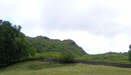
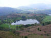
A very clear path leads south-east off the summit of Loughrigg Fell. After a short distance this path drops down into a valley that runs between scree slopes that look unusually industrial. Soon after this the path reaches an area where runs across a grassy shelf, with steep slopes to the left - at this point head right to the edge of the grassy to get a good view down to Loughrigg Tarn. The path then runs to the left of a rocky outcropping, before reaching a crossroads overlooking a line of tiny tarns. Turn right at the cross roads onto a path that very quickly curves around to the left and drops down towards a large marshy plateau (Black Mire).
6: NY 356 044
This path eventually reaches a junction where several paths join close to the stream that runs across the plateau. Turn back and right onto a slightly raised path that runs south-west, running around the southern flanks of the fell. This path soon becomes a minor track that runs alongside the wall that separates the fields to the left from the open fell to the right. Continue along this track until it turns sharply to the left and drops down past a small clump of trees to reach a farm road at a T-Junction.
7: NY 347 040
At the T-junction continue in the same direction (down the leg of the T). Follow this minor road as it runs west, then curves left at the next farm (Tarn Foot) and joins a road. Turn right onto this road, which almost immediately reaches another T junction, where we turn left. This road brings us down onto the main road at Skelwith Bridge.
8: NY 344 035
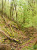
Head along the verge towards the bridge. Just before the road crosses the bridge, turn right onto a signposted footpath. This path heads towards a recently built shop, but just before entering its car park swings away to the right (signposted) and follows a lane that runs through the yard of a stone merchant (with some interesting pieces of slate work on display). At the end of the stone yard the track turns into a path that runs alongside the River Brathay, past Skelwith Force and all the way back to Elterwater village.
9: NY 327 047
The riverside path eventually runs past another NT car park in the centre of Elterwater and reaches the road. Turn right onto this road, and follow it as it runs all the way through the village and back to the main road into Great Langdale. Cross this road and follow the side road as it continues on back to our car park.
