
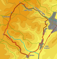
 This walk combines a visit to the Carding Mill Valley with an ascent of the Long Mynd, one of the most dramatic Shropshire landmarks. Carding Mil Valley is a classic mountain valley, steep sided, carved by a mountain brooke and interrupted by the waterfall of Light Spout, while Pole Hill, the highest point on the Long Mynd, is a spectacular viewpoint, with views over the Shropshire Hills and a large part of the Welsh Mountains,
Ascent: 1,700ft/ 510m
Length: 9.5 miles/ 15km
Map: Long Mynd and Wenlock Edge (Explorer Maps) (Explorer Maps)
Last Walked: 10 April 2007
Past the waterfall the path now begins to deviate a little from the original right of way, to avoid areas that have been badly eroded. The OS map shows that right of way following the stream all the way up the valley to the top of the ridge, reaching it close to a Tumulus and a shooting box. The current soon leaves the valley bottom, and climbs up onto the edge of the moor to the right, reaching the ridge line about a fifth of a mile to the right of the original path.
![]() For the first quarter of a mile past the waterfall, the new path runs half way up the right hand side of the valley. After that distance, a small side valley leaves to the right. A sizable path curves away to the right, following the line of the side valley, but our path drops down to cross the side valley, before climbing back up onto the moors to the right of the main valley. After a short distance our path reaches a grassy track. Turn left onto this track, and follow it as it climbs up towards the top of the Long Mynd ridge.
For the first quarter of a mile past the waterfall, the new path runs half way up the right hand side of the valley. After that distance, a small side valley leaves to the right. A sizable path curves away to the right, following the line of the side valley, but our path drops down to cross the side valley, before climbing back up onto the moors to the right of the main valley. After a short distance our path reaches a grassy track. Turn left onto this track, and follow it as it climbs up towards the top of the Long Mynd ridge.
![]() About a quarter of a mile past the small side valley, our path reaches the top of the Long Mynd ridge. A number of clear paths and tracks run along the top of this ridge - on my last visit there were two major paths and at least two minor ones. Cross over the first major path (which is close to being a track), and then turn left onto the second major path, and follow it as it climbs gently along the ridge line.
About a quarter of a mile past the small side valley, our path reaches the top of the Long Mynd ridge. A number of clear paths and tracks run along the top of this ridge - on my last visit there were two major paths and at least two minor ones. Cross over the first major path (which is close to being a track), and then turn left onto the second major path, and follow it as it climbs gently along the ridge line.
After another quarter of a mile our path reaches a minor road (and another small car park). Cross over the road and follow the path that continues on in the same direction, climbing up the ridge line all the way to Pole Bank, the highest point on the Long Mynd.
We stay on this road until we reach the ridge that runs east to Minton Hill, Packetstone Hill and on to the village of Minton. This is the second ridge that we reach after joining the road - the first leads to Round Hill and Little Stretton.
We join the road as it passes across the head of the valley that runs to the north of Round Hill. We then pass Pole Cottage, and a small car park, before reaching the major track that heads along the Round Hill Ridge. We ignore this track, and continue on along the road as it passes across the head of the valley between Round Hill and Minton Hill. From here we can see a distant part of our route, a track that runs around the northern slopes of Minton Hill.
About a quarter of a mile before our turn, the heather moor to the right of the road is replaced by grass. At this point we can look straight down the valley to our left.
We now have two choices of route. Our preferred route follows the official right of way along the northern side of the ridge, but for the first part of this route there is no clear path, so we have to make our own way across the heather.
![]() This route leaves the road just before it begins to climb again for the first time since Pole Cottage. We pass the western tip of the valley to the north of the ridge, and then turn left, and head east through the heather, picking our way along a series of sheep tracks. Keep the valley close to the left, but don't drop down into it. Minton Hill now forms the skyline ahead of us - aim to the left of the summit.
This route leaves the road just before it begins to climb again for the first time since Pole Cottage. We pass the western tip of the valley to the north of the ridge, and then turn left, and head east through the heather, picking our way along a series of sheep tracks. Keep the valley close to the left, but don't drop down into it. Minton Hill now forms the skyline ahead of us - aim to the left of the summit.
![]() After just over a third of a mile in the heather, we reach a small side valley that that cuts across the ridge. Drop down into this minor side valley, cross the boggy area at the base and then climb back out on the opposite side - rather annoyingly there is an obvious path heading out of the valley. (we should lose no more than twenty or third feet of height here). Just under 200 feet after crossing the valley bottom, our path we reach that track that we saw earlier.
After just over a third of a mile in the heather, we reach a small side valley that that cuts across the ridge. Drop down into this minor side valley, cross the boggy area at the base and then climb back out on the opposite side - rather annoyingly there is an obvious path heading out of the valley. (we should lose no more than twenty or third feet of height here). Just under 200 feet after crossing the valley bottom, our path we reach that track that we saw earlier.
If this cross country route does not appeal, then continue on along the road as it begins to gently climb. After about 700 feet turn left onto a track that runs along the southern flank of the ridge. Follow this track as it runs downhill toward the lowest point between the road and Minton Hill. Ignore any minor paths, and just before that lowest point turn left onto the first side-track that you reach. Follow this track for 200 feet. At this point the main track splits and twists to the left, while a footpath leaves to the right. Turn right onto this footpath, which runs around the northern slopes of Minton Hill,
![]() Having hugged the northern slopes of the ridge for some way, the track now swings to the right, and passes between Minton Hill to the right and the Packetstone Hill to the left. It is well worth taking a diversion onto Packetstone Hill, which
Having hugged the northern slopes of the ridge for some way, the track now swings to the right, and passes between Minton Hill to the right and the Packetstone Hill to the left. It is well worth taking a diversion onto Packetstone Hill, which
Our track actually runs all the way along the ridge down into the village of Minton, but it is worth taking a diversion onto Packetstone Hill. After visiting this viewpoint, return to the path, and follow it curves around to the left, passing to the right of a steep sided valley.
![]() At the base of the valley our path takes us across a small dam at the base of a reservoir, and then reaches a crossroads in the path. Cross straight over this crossroads, and follow the path as it climbs back up out of the valley. We follow this path as it climbs around the right hand flank of this final hill. After about a fifth of a mile this path reaches a small road. Cross over the road, and follow the path as it curves around to the left back into Carding Mill Valley.
At the base of the valley our path takes us across a small dam at the base of a reservoir, and then reaches a crossroads in the path. Cross straight over this crossroads, and follow the path as it climbs back up out of the valley. We follow this path as it climbs around the right hand flank of this final hill. After about a fifth of a mile this path reaches a small road. Cross over the road, and follow the path as it curves around to the left back into Carding Mill Valley.