
 Lingmoor Fell is the high ground that seperates Great and Little Langdale, but despite such a prominant position its summit is often quiet. Although Lingmoor Fell is one of the lower fells in the Langdale scene it is an excellent viewpoint, especially for the Langdale Pikes from the summit and over Windermere on the way up.
Ascent: 1,250ft
Length: 3.5 miles
Map: Map: The English Lakes - South Eastern Area (OS Explorer Map Active)
Last Walked:
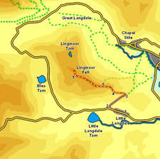
We start in the village of Little Langdale, where there is a limited amount of roadside parking.
![]() At the end of this field the path passes through another wall. A minor path continues along the foot of the fell, but our route takes us to the right, where a well build footpath climbs up the side of the fell, zig-zagging as it goes.
At the end of this field the path passes through another wall. A minor path continues along the foot of the fell, but our route takes us to the right, where a well build footpath climbs up the side of the fell, zig-zagging as it goes.
![]() Towards the top of the climb a path branches off to the left - ignore this path and continue along the main path, which after passing between small crags on both sides turns left and climbs up the eastern flank of the fell. We follow this path all the way to the summit. After a short distance we come within site of a stone wall that runs along the top of the fell - our path stays close to this wall most of the way to the summit.
Towards the top of the climb a path branches off to the left - ignore this path and continue along the main path, which after passing between small crags on both sides turns left and climbs up the eastern flank of the fell. We follow this path all the way to the summit. After a short distance we come within site of a stone wall that runs along the top of the fell - our path stays close to this wall most of the way to the summit.
![]()
![]() The route to the top is straight but not level - we reach two false summits before the real top. After the second false summit the wall turns away to the left, while the path continues on for a short distance, before we turn right to follow it as it climbs up the front of Brown How (with a short gentle scramble required). The path then continues across the summit plateau before crossing a stile to reach the summit.
The route to the top is straight but not level - we reach two false summits before the real top. After the second false summit the wall turns away to the left, while the path continues on for a short distance, before we turn right to follow it as it climbs up the front of Brown How (with a short gentle scramble required). The path then continues across the summit plateau before crossing a stile to reach the summit.