
 This walk takes us from the village of Youlgreave, located on the level ground between the Rivers Bradford and Lathkill, into Lathkill Dale, one of the classic Peak District limestone valleys. Further upstream the Lathkill often runs dry or hides underground, but here it runs over a series of weirs, creating a series of attractive ponds.
Ascent: 1,300ft
Length: 7.5 miles
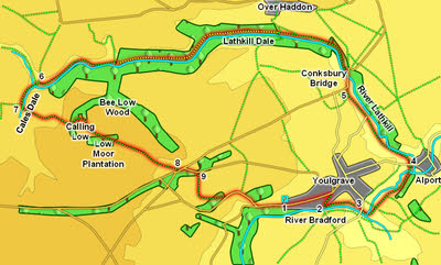
Map:
Last Walked: December 2013
We start at a car park at the western end of Youlgrave Village (on the road to Middleton)
![]() Turn right onto this road, cross the bridge and then turn left onto a footpath that runs alongside (and normally a little above) the Lathkill. We are going to follow this path for about two and a half miles. This section of the river falls into three general sections. In the first part we pass a series of weirs built to create pools used for fish breeding. This brings us level with Over Haddon, where we pass a river-side house.
Turn right onto this road, cross the bridge and then turn left onto a footpath that runs alongside (and normally a little above) the Lathkill. We are going to follow this path for about two and a half miles. This section of the river falls into three general sections. In the first part we pass a series of weirs built to create pools used for fish breeding. This brings us level with Over Haddon, where we pass a river-side house.
![]()
![]() The next section is a permissive footpath, running through woodland with signs of mining, including Bateman's House (across a footbridge), with an unusual underground feature. We emerge from the woods at a point where there are side valleys on both sides of the river.
The next section is a permissive footpath, running through woodland with signs of mining, including Bateman's House (across a footbridge), with an unusual underground feature. We emerge from the woods at a point where there are side valleys on both sides of the river.
![]() Finally we run along the foot of the open hillside, until we reach a footbridge opposite Cales Dales, a larger side valley that runs south from the Lathkill.
Finally we run along the foot of the open hillside, until we reach a footbridge opposite Cales Dales, a larger side valley that runs south from the Lathkill.
![]() After a short distance the valley splits - the main branch continues on south, without a path. A side valley runs off to the right, carrying one path. Our route is to the left - look for a path that dips down to cross the valley then climbs steeply up the opposite slope, following a well constructed rocky staircase up to the top.
After a short distance the valley splits - the main branch continues on south, without a path. A side valley runs off to the right, carrying one path. Our route is to the left - look for a path that dips down to cross the valley then climbs steeply up the opposite slope, following a well constructed rocky staircase up to the top.
![]() This now brings us to a typical patch of Peak District limestone fields, with distant views and neat stone walls. The path runs across three fields to reach Calling Low farm, where it skirts around to the left of the buildings - the route was visible underfoot on my visit, heading across the middle of the first field, toward the opposite corner of the second field and cutting the curner in the third. It is then clearly signposted as it passes Calling Low. In the next large field head diagonally across towards Low Moor Plantation. The path cuts across a corner of these woods, then across the end of one large field, and across the middle of a larger one, turning to the right about half way across). This brings us to a strip of smaller fields bordering a road - the path turns left inside the first field and runs diagonally across them to the road.
This now brings us to a typical patch of Peak District limestone fields, with distant views and neat stone walls. The path runs across three fields to reach Calling Low farm, where it skirts around to the left of the buildings - the route was visible underfoot on my visit, heading across the middle of the first field, toward the opposite corner of the second field and cutting the curner in the third. It is then clearly signposted as it passes Calling Low. In the next large field head diagonally across towards Low Moor Plantation. The path cuts across a corner of these woods, then across the end of one large field, and across the middle of a larger one, turning to the right about half way across). This brings us to a strip of smaller fields bordering a road - the path turns left inside the first field and runs diagonally across them to the road.