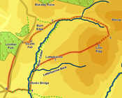
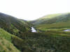
 This walk takes us into the upper Calder valley, a quiet area dominated by smooth grassy hills. Our route takes us close to the source of the Calder, before climbing up onto the hills from the valley of Whoap Beck. From there we reach the summit of Lank Rigg, before returning via Latterbarrow, Monks Bridge and Coldfell Gate.
This walk is best done after dryer weather - the descent from Lank Rigg can be unpleasantly boggy after heavy rain, and Latterbarrow Beck becomes quite an obstacle.
Ascent: 1,800ft
Length: 8 miles
Map: The English Lakes - North Western Area (OS Explorer Map Active)
Last Walked: 1 September 2009
We start from a small parking area to be found where the woods of Lowther Park reach the Coldfell Road, normally a quiet mountain road but at the wrong time of day something of a rat run between Sellafield and Ennerdale.
1: NY 060 119
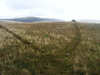
A thin but clear path heads north-east from the car park and climbs up to the top of Swarth Fell. Follow this path.
2: NY 064 120
From the top of Swarth Fell we get a good view of the upper Calder Valley. A number of different paths run north-east, past Burn Edge and up to the northern end of the valley where the river swings away to the east. Look for a path than runs to the right of Burn Edge (the next summit to the north of Swarth Fell), gently loosing altitude as it runs roughly parallel to the river.
3: NY 073 128
About three-quarters of a mile after leaving Swarth Fell our path joins a track that runs between Burn Edge and Blakeley. Turn right onto this track, and follow it as it runs just to the left of the Calder, which is now heading east.
4: NY 084 130
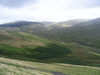
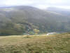
 After just over half an hour on this track the Calder swings north, between Blakeley and Whoap. Our track crosses the river, and continues on to the east, with the main track climbing up Whoap. A few feet after crossing the Calder look out for a smaller path that branches off to the right. Take this path and follow it as it runs east, into the valley between Whoap and Lank Rigg, with Whoap Beck to
 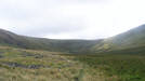 the right. At one point the path splits in two, with the right hand branch running nearer to the valley bottom and the left hand branch cutting across the slopes of Whoap - take either path, as they join towards the upper end of the valley.
At the top of the valley the path curves to the right, and climbs up the end of the valley onto the ridge that joins Whoap to Lank Rigg.
5: NY 095 123
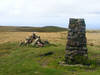
This brings us onto a path that runs between the two fells. Turn right, and follow this path all the way onto the summit of Lank Rigg.
6: NY 091 119
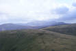
No other obvious paths lead off the top of Lank Rigg, but this doesn't really matter - the western and southern slopes are all gentle enough to be used for a descent. Our route leads the summit to the west, heading towards the subsidiary summit of Latter Barrow (aim just to the left of the top of Swarth Fell, on the far side of the Calder.
7: NY 074 114
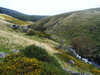
Latter Barrow is the second of two subsidiary summits on the western slopes of Lank Rigg. Once again there are no clear paths, but any of the western slopes can be used to reach the Calder. The best route is to head south-west, towards the junction between the Calder and Latterbarrow Beck. This brings us to a footpath that follows the Calder, but that is often rather wet to the north of Latterbarrow Beck. Turn left onto this path, and follow it as it runs south alongside the river.
8: NY 064 101
This path brings us to Monk's Bridge, a pack horse bridge across the river often said to be the most beautiful in the district. A short distance past this bridge a more modern footbridge crosses the river. Use this bridge and then follow the track that runs up the small valley of Friar Gill.
9: NY 055 101
This track brings us back to the Coldgate Road. Turn right and follow this road all the way back to the car, taking advantage of a path that runs along the wide grassy verge to the left of the road.
