
 This walk starts in the beautiful valley of Great Langdale, climbs fairly rapidly to the top of the Langdale Pikes, then stays at a high level, exploring the plateau behind the pikes. It visits the summit of High Raise, un dramatic itself but a superb viewpoint, especially for the Scafell group and towards Derwent Water, and normally clear of the crowds to be found on the pikes themselves.
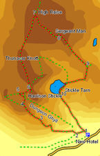
The walk starts by climbing 1,750 feet in one and a quarter miles, but having gained that height we maintain it for much of the rest of the walk, giving us fantastic views across the heart of the Lake District.
Ascent: 2,550ft/ 780m
Length: 5.9 miles/ 9.5km
Map: Explorer 6
Last Walked: 6 October 2007
![]() Cross the first wall. Here the path splits again - take the right hand path following the line of the wall. At a second wall, where the path splits yet again, turn left, cross the Dungeon Ghyll and follow the obvious path as it climbs up the west bank of the Ghyll.
Cross the first wall. Here the path splits again - take the right hand path following the line of the wall. At a second wall, where the path splits yet again, turn left, cross the Dungeon Ghyll and follow the obvious path as it climbs up the west bank of the Ghyll.
This path climbs up towards the first set of crags, at Mark Gate, following a ridge to the left of the Dungeon Ghyll. The path is obvious as it climbs up to the crags. Follow a signposted diversion that winds up through the rocks, eventually emerging onto a saddle between the top of these crags and the main Langdale Pikes.
![]() This path will be our way on later. For the moment turn right, and follow it to the top of Harrison Stickle. This is a fine rocky outcropping with spectacular views into Langdale, and with a super all round view.
This path will be our way on later. For the moment turn right, and follow it to the top of Harrison Stickle. This is a fine rocky outcropping with spectacular views into Langdale, and with a super all round view.
Once you have finished on this summit, return north along the path to the saddle, then continue north at the crossroads and follow this path to the rounded summit of Thunacar Knotts.
From there the path to High Raise is also obvious, heading almost directly towards the High White Stones at the summit of the next fell. Follow this path to the summit cairn, triangulation point and small shelter on top of High Raise. The view west is particularly fine, down into Langstrath and up towards Derwent Water and Keswick.
![]() The path off the summit of High Raise is not entirely obvious. To your east you should be able to see a couple of tiny summit tarns. Follow the narrow path that leaves the summit area and heads between these tarns (In mist I would suggest turning back at this point, following the clear path back to Harrison Stickle, and descending via our original route).
The path off the summit of High Raise is not entirely obvious. To your east you should be able to see a couple of tiny summit tarns. Follow the narrow path that leaves the summit area and heads between these tarns (In mist I would suggest turning back at this point, following the clear path back to Harrison Stickle, and descending via our original route).
As soon as you have passed between the small tarns, turn right and head towards a fencepost visible on the skyline. The crowds on the Langdale Pikes may also be visible poking above the skyline. Close to this fence post you will meet a clear path. Turn left and follow it towards Sergeant Man.
This path tends to follow the left hand side of the ridge, with views down towards Easedale Tarn. The path does not follow the route of the right of way marked on the OS maps. The right of way is marked as turning to the right just past a small tarn, at the point where the path emerges from the main crags. Instead, it continues on along the top of the ridge, still generally tending to the left for much further than is marked.
Eventually, after skirting around a very wet patch, our path reaches a t-junction. Turn right onto the path heading down towards Stickle Tarn. The tarn itself soon comes into the view. The path itself is clear underfoot, if not always visible from a distance.