
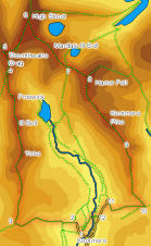
 The Kentmere Round is one of the better known challenges in fell walking. Starting in the remote quiet valley of Kentmere it visits a total of eight peaks, amongst them the dramatic Ill Bell and High Street, the highest of the eastern fells.
This is a challenging walk, and will need a full day.
There is a limited amount of parking close to the church in Kentmere and there may be field parking at some times of year. Be aware that the road into Kentmere is very narrow.
Ascent: 3,900ft/ 1,170m
Length: 13.5 miles/ 21.6km
Map: Explorer 07 The English Lakes South East
Last Walked: 10 August 2005
![]() When the road reaches these houses (the first after leaving the area immediately around the church) turn left onto the lane that runs west between the two houses. This is the start of the road that leads up the Garburn Pass.
When the road reaches these houses (the first after leaving the area immediately around the church) turn left onto the lane that runs west between the two houses. This is the start of the road that leads up the Garburn Pass.
![]() After passing between The Nook and Greenlands, the road heads towards a line of houses. One track leads on through a gap in these houses, but our route turns right just before the houses and curves around them to the north. Follow this track west as it climbs all the way to the top of Garburn Pass.
After passing between The Nook and Greenlands, the road heads towards a line of houses. One track leads on through a gap in these houses, but our route turns right just before the houses and curves around them to the north. Follow this track west as it climbs all the way to the top of Garburn Pass.
![]() After a steady climb we reach the top of the pass. The track passes through a gate, runs straight across the top of the pass and then turns sharply to the left before heading back down hill.
After a steady climb we reach the top of the pass. The track passes through a gate, runs straight across the top of the pass and then turns sharply to the left before heading back down hill.
We have a choice of two routes here, both leaving the track to the right and heading straight up the ridge to Yoke, Ill Bell, Froswick and eventually Thornthwaite Crag. The first path leaves the track immediately after we pass through the gate, and follows the line of the wall
![]() The second path is probably the better route. This leaves the track at the western end of the pass, just before the sharp left turn, and heads north up the ridge. This path is somewhat less rocky, and offers us our first views west towards the heart of the Lake District. The two paths merge after just under a mile.
The second path is probably the better route. This leaves the track at the western end of the pass, just before the sharp left turn, and heads north up the ridge. This path is somewhat less rocky, and offers us our first views west towards the heart of the Lake District. The two paths merge after just under a mile.
![]() We now follow this path north to our first three summits. Follow the obvious path, always climbing, until it reaches the summit of Yoke. From here the path onwards to Ill Bell is obvious, heading north along the ridge.
We now follow this path north to our first three summits. Follow the obvious path, always climbing, until it reaches the summit of Yoke. From here the path onwards to Ill Bell is obvious, heading north along the ridge.
![]() The same is true on Ill Bell and Froswick. On both of those summits the path onwards jinks a little to the left to avoid crags, following the ridge line all the way, dropping down slightly after each summit before climbing back up to the next target.
The same is true on Ill Bell and Froswick. On both of those summits the path onwards jinks a little to the left to avoid crags, following the ridge line all the way, dropping down slightly after each summit before climbing back up to the next target.
As we approach Thornthwaite Crag the ridge begins to widen, to form a triangle of more level ground. Here there are two junctions in the path. At the first a major path joins us from behind and to the left, climbing up out of Troutbeck. Here we continue on along the ridge line.
![]() Soon after this the path branches. The right hand branch heads straight onto High Street, but we are going to take the left hand branch, which will take us on a worthwhile diversion to the top of Thornthwaite Crag, with its distinctive cairn perched on the line of a stone wall.
Soon after this the path branches. The right hand branch heads straight onto High Street, but we are going to take the left hand branch, which will take us on a worthwhile diversion to the top of Thornthwaite Crag, with its distinctive cairn perched on the line of a stone wall.
The summit of High Street is a large triangular plateau, with the highest ground at the northern tip of the triangle. A number of paths cross the summit. Although the summit plateau itself is not all that interesting, the views from its flanks are well worth a look. The views east across Blea Water and Haweswater are particularly dramatic.
Once we have finished on top of High Street our next target is Mardale Ill Bell, at the south eastern corner of the summit plateau. The easiest way to reach our target is to return to the trig point at the summit of ![]() High Street. From there follow the wall south until a very clear path branches off to the left. This path runs south east across the summit of High Street, before climbing up onto Mardale Ill Bell.
High Street. From there follow the wall south until a very clear path branches off to the left. This path runs south east across the summit of High Street, before climbing up onto Mardale Ill Bell.
We follow this path as it runs over the summit of Mardale Ill Bell and then continues on, heading south east, as it drops down to the top of Nan Bield Pass
![]() At the top of the pass there is a crossroads in the path. Left leads down into Mardale, right into Kentmere while straight ahead climbs back up onto Harter Fell. Needless to say our route heads straight ahead, climbing back up onto the tops. Follow this path as it climbs up the rocky ridge that leads onto Harter Fell. The fells on the eastern side of Kentmere are very different in character those on the western side, with broad and often somewhat damp summits. At the top of the rocky climb our path heads east across a grassy plateau towards the trig point at the summit of Harter Fell.
At the top of the pass there is a crossroads in the path. Left leads down into Mardale, right into Kentmere while straight ahead climbs back up onto Harter Fell. Needless to say our route heads straight ahead, climbing back up onto the tops. Follow this path as it climbs up the rocky ridge that leads onto Harter Fell. The fells on the eastern side of Kentmere are very different in character those on the western side, with broad and often somewhat damp summits. At the top of the rocky climb our path heads east across a grassy plateau towards the trig point at the summit of Harter Fell.
If we still have the energy, it is worth makes a brief diversion to visit Goat Scar, a good viewpoint overlooking Longsleddale. Just under half a mile after leaving the summit of Kentmere Pike the path splits into two and leaves the line of the fence. The right hand branch heads due south. The left hand branch heads south east, cutting off a corner created by a right angle in the fence. If we do not want to visit Goat Scar, then we take this left hand branch, and follow it to the point where our fence meets a stone wall.
![]() If we do want to visit Goat Scar, then at the junction in the path ignore both of these paths, and instead continue to follow the fence as it runs along the top of the ridge line. After a short distance we reach a corner in the fence, where it turns right on its way to meet the stone wall mentioned above. To reach Goat Scar cross the fence here (carefully and without causing any damage), and carefully follow the small paths that lead out onto this miniature summit. Return the same way, cross over the fence and follow it down hill to the junction with the stone wall.
If we do want to visit Goat Scar, then at the junction in the path ignore both of these paths, and instead continue to follow the fence as it runs along the top of the ridge line. After a short distance we reach a corner in the fence, where it turns right on its way to meet the stone wall mentioned above. To reach Goat Scar cross the fence here (carefully and without causing any damage), and carefully follow the small paths that lead out onto this miniature summit. Return the same way, cross over the fence and follow it down hill to the junction with the stone wall.
Our two routes have now come back together at the stone wall. Once across that wall, our path continues south east, cutting off another corner in the fence, and then follows the line of the wall down into a pass. In places this path is a bit of a rocky scramble, so take care!
It is possible to return to our starting point on the roads, but there is a more interesting route. After a quarter of a mile on the road look out for a foot path that leaves the road to the right. Follow this footpath across a first field. At the far end of this field a stile leads into a narrow lane, which we immediately leave using a stile on the opposite wall.
We follow this path as it crosses another field, before crossing the River Kent on a foot bridge and climbing back up to join another lane on the far side of the river. Turn left onto the lane. Just past the first buildings we meet the track splits in two. Either track will take us back to the church, I used the left hand branch, so keep left and follow this track all the way back to the church, and our starting point.