
 This walk gets us two summits in a single walk, starting with the misleadingly dominant Irton Pike, which looms over parts of the Cumbrian coast, but is actually connected by almost level ground to the ridge that climbs up to our second summit, Winn Rigg and the long ridge that runs above the Wast Water screes.
Ascent: 1,500ft
Length: 5 miles
Map: Lakes South-West
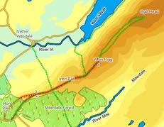
We start from the small car park on the road that cuts across the southern side of Irton Pike
Turn right out of the car park, and head along the road for a few feet until you reach the start of a track which heads off into the woods to the right. Turn onto this track and follow it as it climbs across the eastern slope of the fell. After just under 500ft turn left onto a track that runs across the southern flank of Irton Pike. Follow this track for a little longer.
![]() The only difficult moment on the walk is finding the start of the path that runs up the front of the pike. When the slopes of the Pike were covered in trees it was no doubt easier to spot, but now the first few steps are rather indistinct. Look for a narrow path that starts by a silver birch and a distinctive tree-stump, with a series of horizontal cuts. A large gate on the road should be visible to the left. Turn right onto this path and follow it as it climbs up the front of Irton Pike, getting clearer as it goes.
The only difficult moment on the walk is finding the start of the path that runs up the front of the pike. When the slopes of the Pike were covered in trees it was no doubt easier to spot, but now the first few steps are rather indistinct. Look for a narrow path that starts by a silver birch and a distinctive tree-stump, with a series of horizontal cuts. A large gate on the road should be visible to the left. Turn right onto this path and follow it as it climbs up the front of Irton Pike, getting clearer as it goes.
If time allows it is worth extending the walk to include Illgill Head, following either of the paths that link the two summits (the one that runs close to the top of the screes is most dramatic). In any case, this route requires us to return along the same path, so after visiting the summits head back down the slope, past Greathall Gill and down to the junction at step 3.
![]()
![]()
![]()