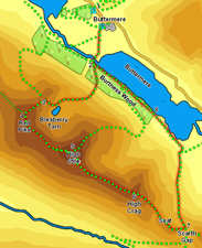
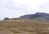
 This is one of the classic Lake District ridge walks. Starting with the famous frontal route up Red Pike, it continued along the High Stile Range, which provides the towering south wall to the Buttermere Valley, visiting three major summits before dropping down Gamlin End to Scarth Gap, a busy foot pass between Buttermere and Ennerdale. The route even finishes with a delightful lake side stroll through the woods around Buttermere!
Ascent: 3,000ft
Length: 8 miles
Map: The English Lakes - North Western Area (OS Explorer Map Active)
Last Walked: 2010
We start from the National Trust car park just above Buttermere village.
1: NY 172 172
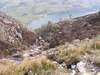
Turn right out of the car park and follow the road down into Buttermere. Cross the bridge and then turn right into the village. Take the track that passes to the left of the Fish Hotel, and follow it as it zig-zags down to Buttermere lake. Turn right at the lake shore and head towards the footbridge across Buttermere Dubs.
2: NY 172 162
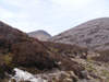
Follow the path that runs around the lake shore from the bridge into Burtness Wood. Just inside the woods the path splits - take the right hand path, a rocky staircase that climbs up through the woods and then continues on up the open fell side following a zig-zag path up to
Bleaberry Tarn. From the tarn follow the path that climbs diagonally up the slope to the right, heading for The Saddle between Red Pike and Dodd
3: NY 162 155
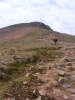
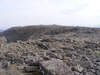
This brings us to the final part of the ascent of Red Pike, the famous scramble up the screes. This isn't quite as bad as it looks from a distance. The path follows the wide but steep ridge that connected Red Pike to Dodd. Towards the top the path splits in two, with one curving around to the left to avoid a rocky outcrop and the other continuing on up a gully. I followed the gully path which was steep but acceptable. The top of the gully is only a few feet from the summit of Red Pike.
4: NY 160 154
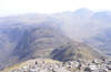
A clear path runs left from the summit of Red Pike towards High Stile, the centre of the range and its highest peak. Take some time to explore the summit of High Stile, with its two main summits and
5: NY 168 147
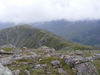
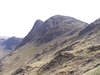
Another clear path follows the narrow ridge from High Stile to
High Crag. This starts with a 250ft descent from the top of High Stile, and finishes with a 100ft climb onto High Crag, but is otherwise fairly level. This is one of my favourite ridge walks - narrow enough to give great views but wide enough to feel totally safe
6: NY 180 140
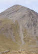
Our route continues straight over the summit of High Crag onto Gamlin End, the steep scree-covered eastern end of the ridge. As with the ascent of Red Pike this path is never quite as bad as it looks from a distance, although the path down the
scree slopes at the top can be quite slippery, and requires care. This is followed by a steep descent down a well maintained path which brings us to the col between High Crag and Seat. Ignore the short-cut that heads off to the left and follow the main path across Seat, taking the time to visit its quiet summit before heading on to Scarth Gap.
7: NY 189 133
Turn left at Scarth Gap and follow the very clear path down from Scarth Gap pass down to Buttermere lake. This brings us to the south-eastern corner of the lake. Either side of the lake can be used to return to the village - here we will turn left and follow the southern path through Burtness Wood.
8: NY 184 153
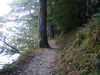
Just as we enter the woods the path splits into a main upper path and a smaller lower path to the right. Take this lower path - a delightful walk along the lakeshore - and follow it all the way back to the bridge over Buttermere Dubs. From there retrace your steps to the village and then the car park.
