
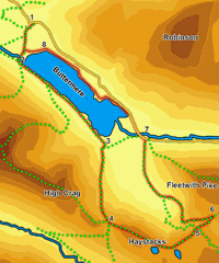
 This is a particularly beautiful walk that combines a walk around the lake at Buttermere with an ascent of Hay Stacks, famously Wainwright's favourite mountain. The walk begins and ends in the village of Buttermere, follows the southern shore of the lake before climbing the mountain and then returns along the northern bank, giving us spectacular views back to Haystacks.
Haystacks itself may not be the highest of Lakeland peaks, but its location makes it a perfect viewpoint. It provides particularly good views of Pillar and Great Gable. The summit itself is one of the most interesting in the Lakes, with a scattering of tarns, most famously Innominate Tarn.
Ascent: 2,350ft
Length: 8.7 miles
Map: Explorer 004 English Lakes North West
Last Walked: 12 August 2005
For the purposes of this walk, we start from the National Trust car park just west of the village of Buttermere.
From the National Trust car park head downhill into Buttermere (turn right out of the car park). At the bottom of the hill, cross over Mill Beck and then take the first right turn.
This side road soon splits around a large building. The right hand branch heads into the National Park car park, while the left hand branch heads down to the lake, so take the left hand branch.
Just outside the village the track turns sharply to the left. After a short distance it then turns back to the right and splits into two - take the left hand branch here and follow the path to the edge of Buttermere.
At the lake shore turn right, heading towards Buttermere Dubs, the stream that links Buttermere and Crummock Water. Cross this stream on the well built bridge, and then follow the obvious path as it turns gently to the left (at this point you may wish to take a quick diversion to look at Sourmilk Gill which reaches the lakeshore here).
A number of different paths run through the woods on the southern shore of Buttermere. The clearest, and best, runs close to the lake shore. Take this path and follow it
![]() At the top of the path turn left and follow the path that climbs up the western end of Hay Stacks. After a short distance this turns into a bit of a scramble, but the correct way up is rarely in any doubt.
At the top of the path turn left and follow the path that climbs up the western end of Hay Stacks. After a short distance this turns into a bit of a scramble, but the correct way up is rarely in any doubt.
![]() The scramble ends at the highest point on the summit of Hay Stacks, at the western end of the long summit plateau. An obvious path heads across the top of the mountain, visiting Innominate Tarn before dropping down to Blackbeck Tarn, but it is well worth exploring this delightful summit, a miniature mountain landscape in its own right. A diversion to the southern side of the plateau gives spectacular views into Ennerdale, across to Pillar and up the valley to Great Gable.
The scramble ends at the highest point on the summit of Hay Stacks, at the western end of the long summit plateau. An obvious path heads across the top of the mountain, visiting Innominate Tarn before dropping down to Blackbeck Tarn, but it is well worth exploring this delightful summit, a miniature mountain landscape in its own right. A diversion to the southern side of the plateau gives spectacular views into Ennerdale, across to Pillar and up the valley to Great Gable.
![]()
![]()
The route off Haystacks to the east is rather clearer on the ground than on the map. Follow the main path that runs across the summit plateau, past Blackbeck Tarn and towards Warnscale Beck (just past Blackbeck Tarn the path climbs up a narrow staircase, then splits, but these paths soon come back together).
Paths run down both sides of the beck. We want the path on the far side of the beck, which curves around Warnscale Bottom giving great views back towards Hay Stacks. The path from Blackbeck Tarn runs straight for about a quarter of a mile, then curves to the left, before splitting in two. The left hand path runs down a slight ravine while the right hand path climbs up slightly onto Little Round How. Take the right hand path and continue across the top of the how and on to Warnscale Beck